Cotronei geodata
Cotronei (Calabria) is a seat of a third-order administrative division; located in Italy in Europe/Rome (GMT+2) time zone. With population of 5,121 people, there are 1910 cities with bigger population in this country. Compared to other cities in Italy, 92% of cities are located further ↑North; 97.5% of cities are located further ←West and 82.2% of cities have lower elevation than Cotronei. Note1


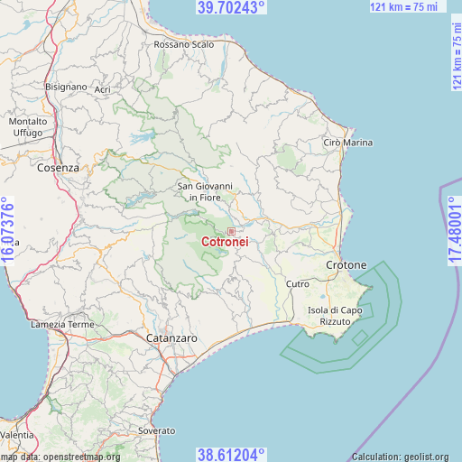
Cotronei GPS coordinates[2]
39° 9' 33.66" North, 16° 46' 36.768" East
| Map corner | latitude | longitude |
|---|---|---|
| Upper-left | 39.70243°, | 16.07376° |
| Center: | 39.15935°, | 16.77688° |
| Lower-right: | 38.61204°, | 17.48001° |
| Map W x H: | 121.2×121.2 km | = 75.3×75.3mi |
| max Lat: | 47.04031° ⇑92% North |
| Cotronei: | 39.15935° |
| min Lat: | ⇓8% South 35.50142° |
| min Long | Cotronei | max Long |
| 6.69888° | 16.77688° | 18.48682° |
| W 97.5%⇐ | ⇒2.5% E |
Elevation
Elevation of Cotronei is 558 m = 1831 ft, and this is 251.3 m = 824 ft above average elevation for this country.
| Max E: |
2085 m = 6841 ft | 17.8% |
| Cotronei | 558 m 1831 ft | |
| Avg. | 306.7 m = 1006 ft | |
Min E: |
-4 m = -13 ft | 82.2% |
See also: Italy elevation on elevation.city.
Geographical zone
Cotronei is located in North temperate zone (between Tropic of Cancer and the Arctic Circle). Distance of this Northern Tropic circle is 1748.2 km =1086.3 mi to South.| Distance of | km | miles | from Cotronei |
|---|---|---|---|
| North Pole | 5653 | 3512.6 | to North |
| Arctic Circle | 3047.1 | 1893.4 | to North |
| Tropic Cancer | 1748.2 | 1086.3 | to South |
| Equator | 4354.1 | 2705.5 | to South |


Nearby cities:
15 places around Cotronei: (largest is in red/bold)
• Belvedere Spinello
11.3 km =7 mi,  62°
62°
• Caccuri
7.4 km =4.6 mi,  0°
0°
• Castelsilano
12.2 km =7.6 mi,  356°
356°
• Cerenzia
9.6 km =6 mi,  5°
5°
• Cerva
15.3 km =9.5 mi,  190°
190°
• Foresta
7.4 km =4.6 mi,  155°
155°
• Marcedusa
15.6 km =9.7 mi, 160°
• Mesoraca
8.9 km =5.5 mi,  173°
173°
• Pagliarelle
3.1 km =1.9 mi,  226°
226°
• Petilia Policastro
5.2 km =3.2 mi,  175°
175°
• Petronà
13 km =8.1 mi, 187°
• Roccabernarda
7.8 km =4.8 mi,  112°
112°
• San Giovanni in Fiore
12.6 km =7.8 mi,  326°
326°
• San Mauro Marchesato
14.2 km =8.8 mi, 114°
• Santa Severina
11.6 km =7.2 mi,  96°
96°
Sources, notices
• [Note1] Compared only with cities in Italy existing in our database
• [Src1] Map data: © OpenStreetMap contributors (CC-BY-SA)
• [Src2] Other city data from geonames.org with taken over terms of usage.
• [Src3] Geographical zone / Annual Mean Temperature by Robert A. Rohde @ Wikipedia
