Borgo Fornari-Pieve geodata
Borgo Fornari-Pieve (Liguria) is a populated place; located in Italy in Europe/Rome (GMT+2) time zone. With population of 1,182 people, there are 6018 cities with bigger population in this country. Compared to other cities in Italy, 52.3% of cities are located further ↓South; 82.1% of cities are located further →East and 66.2% of cities have lower elevation than Borgo Fornari-Pieve. Note1


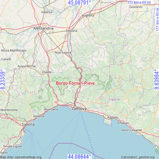
Borgo Fornari-Pieve GPS coordinates[2]
44° 35' 21.588" North, 8° 56' 12.156" East
| Map corner | latitude | longitude |
|---|---|---|
| Upper-left | 45.08791°, | 8.23359° |
| Center: | 44.58933°, | 8.93671° |
| Lower-right: | 44.08644°, | 9.63984° |
| Map W x H: | 111.4×111.4 km | = 69.2×69.2mi |
| max Lat: | 47.04031° ⇑47.7% North |
| Borgo Fornari-Pieve: | 44.58933° |
| min Lat: | ⇓52.3% South 35.50142° |
| min Long | Borgo Fornari-P | max Long |
| 6.69888° | 8.93671° | 18.48682° |
| W 17.9%⇐ | ⇒82.1% E |
Elevation
Elevation of Borgo Fornari-Pieve is 355 m = 1165 ft, and this is 48.3 m = 158 ft above average elevation for this country.
| Max E: |
2085 m = 6841 ft | 33.8% |
| Borgo Fornari-Pieve | 355 m 1165 ft | |
| Avg. | 306.7 m = 1006 ft | |
Min E: |
-4 m = -13 ft | 66.2% |
See also: Italy elevation on elevation.city.
Geographical zone
Borgo Fornari-Pieve is located in North temperate zone (between Tropic of Cancer and the Arctic Circle). Distance of this Northern Tropic circle is 2351.9 km =1461.4 mi to South.| Distance of | km | miles | from Borgo Fornari-Pieve |
|---|---|---|---|
| North Pole | 5049.2 | 3137.4 | to North |
| Arctic Circle | 2443.3 | 1518.2 | to North |
| Tropic Cancer | 2351.9 | 1461.4 | to South |
| Equator | 4957.9 | 3080.7 | to South |


Nearby cities:
15 places around Borgo Fornari-Pieve: (largest is in red/bold)
• Busalla
2.2 km =1.4 mi,  161°
161°
• Casella
7.9 km =4.9 mi,  139°
139°
• Crocefieschi
6.9 km =4.3 mi,  97°
97°
• Fraconalto
4.6 km =2.9 mi,  272°
272°
• Isola del Cantone
6.7 km =4.2 mi,  14°
14°
• Isorelle
3.2 km =2 mi, 141°
• Isoverde
9 km =5.6 mi,  222°
222°
• Mignanego
7.1 km =4.4 mi,  194°
194°
• Pedemonte
9.6 km =6 mi,  184°
184°
• Prelo
9.2 km =5.7 mi, 191°
• Ronco Scrivia
2.9 km =1.8 mi,  21°
21°
• Savignone
4.9 km =3 mi,  124°
124°
• Serra Riccò
8.7 km =5.4 mi, 179°
• Vobbia
8.2 km =5.1 mi,  80°
80°
• Voltaggio
8.2 km =5.1 mi,  295°
295°
Sources, notices
• [Note1] Compared only with cities in Italy existing in our database
• [Src1] Map data: © OpenStreetMap contributors (CC-BY-SA)
• [Src2] Other city data from geonames.org with taken over terms of usage.
• [Src3] Geographical zone / Annual Mean Temperature by Robert A. Rohde @ Wikipedia
