Mignanego geodata
Mignanego (Liguria) is a seat of a third-order administrative division; located in Italy in Europe/Rome (GMT+2) time zone. With population of 1,603 people, there are 4902 cities with bigger population in this country. Compared to other cities in Italy, 51.4% of cities are located further ↓South; 82.5% of cities are located further →East and 58.4% of cities have higher elevation than Mignanego. Note1


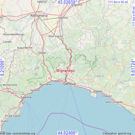
Mignanego GPS coordinates[2]
44° 31' 38.928" North, 8° 54' 50.832" East
| Map corner | latitude | longitude |
|---|---|---|
| Upper-left | 45.02659°, | 8.21099° |
| Center: | 44.52748°, | 8.91412° |
| Lower-right: | 44.02406°, | 9.61724° |
| Map W x H: | 111.5×111.5 km | = 69.3×69.3mi |
| max Lat: | 47.04031° ⇑48.6% North |
| Mignanego: | 44.52748° |
| min Lat: | ⇓51.4% South 35.50142° |
| min Long | Mignanego | max Long |
| 6.69888° | 8.91412° | 18.48682° |
| W 17.5%⇐ | ⇒82.5% E |
Elevation
Elevation of Mignanego is 176 m = 577 ft, and this is 130.7 m = 429 ft below average elevation for this country.
| Max E: |
2085 m = 6841 ft | 58.4% |
| Avg. | 306.7 m = 1006 ft | |
| Mignanego | 176 m = 577 ft | |
Min E: |
-4 m = -13 ft | 41.6% |
See also: Italy elevation on elevation.city.
Geographical zone
Mignanego is located in North temperate zone (between Tropic of Cancer and the Arctic Circle). Distance of this Northern Tropic circle is 2345.1 km =1457.2 mi to South.| Distance of | km | miles | from Mignanego |
|---|---|---|---|
| North Pole | 5056.1 | 3141.7 | to North |
| Arctic Circle | 2450.2 | 1522.5 | to North |
| Tropic Cancer | 2345.1 | 1457.2 | to South |
| Equator | 4951 | 3076.4 | to South |


Nearby cities:
15 places around Mignanego: (largest is in red/bold)
• Borgo Fornari-Pieve
7.1 km =4.4 mi,  14°
14°
• Busalla
5.4 km =3.4 mi,  27°
27°
• Campomorone
3 km =1.9 mi,  229°
229°
• Casella
6.9 km =4.3 mi,  82°
82°
• Ceranesi
2.9 km =1.8 mi,  214°
214°
• Ferriera-Pontasso
3.4 km =2.1 mi,  240°
240°
• Gaiazza
4.2 km =2.6 mi, 233°
• Isorelle
5.8 km =3.6 mi,  40°
40°
• Isoverde
4.3 km =2.7 mi,  272°
272°
• Manesseno
5.6 km =3.5 mi,  168°
168°
• Pedemonte
2.9 km =1.8 mi,  160°
160°
• Piccarello
6.4 km =4 mi,  139°
139°
• Prelo
2.1 km =1.3 mi,  179°
179°
• Santa Marta
3.1 km =1.9 mi, 213°
• Serra Riccò
2.7 km =1.7 mi,  134°
134°
Sources, notices
• [Note1] Compared only with cities in Italy existing in our database
• [Src1] Map data: © OpenStreetMap contributors (CC-BY-SA)
• [Src2] Other city data from geonames.org with taken over terms of usage.
• [Src3] Geographical zone / Annual Mean Temperature by Robert A. Rohde @ Wikipedia
