Isorelle geodata
Isorelle (Liguria) is a populated place; located in Italy in Europe/Rome (GMT+2) time zone. With population of 604 people, there are 8960 cities with bigger population in this country. Compared to other cities in Italy, 52% of cities are located further ↓South; 81.8% of cities are located further →East and 68.2% of cities have lower elevation than Isorelle. Note1


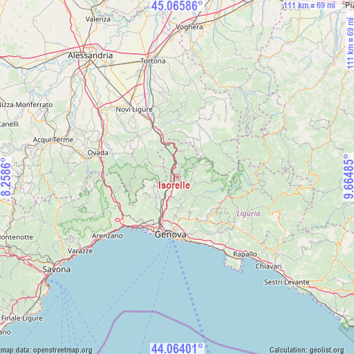
Isorelle GPS coordinates[2]
44° 34' 1.524" North, 8° 57' 42.228" East
| Map corner | latitude | longitude |
|---|---|---|
| Upper-left | 45.06586°, | 8.2586° |
| Center: | 44.56709°, | 8.96173° |
| Lower-right: | 44.06401°, | 9.66485° |
| Map W x H: | 111.4×111.4 km | = 69.2×69.2mi |
| max Lat: | 47.04031° ⇑48% North |
| Isorelle: | 44.56709° |
| min Lat: | ⇓52% South 35.50142° |
| min Long | Isorelle | max Long |
| 6.69888° | 8.96173° | 18.48682° |
| W 18.2%⇐ | ⇒81.8% E |
Elevation
Elevation of Isorelle is 375 m = 1230 ft, and this is 68.3 m = 224 ft above average elevation for this country.
| Max E: |
2085 m = 6841 ft | 31.8% |
| Isorelle | 375 m 1230 ft | |
| Avg. | 306.7 m = 1006 ft | |
Min E: |
-4 m = -13 ft | 68.2% |
See also: Italy elevation on elevation.city.
Geographical zone
Isorelle is located in North temperate zone (between Tropic of Cancer and the Arctic Circle). Distance of this Northern Tropic circle is 2349.5 km =1459.9 mi to South.| Distance of | km | miles | from Isorelle |
|---|---|---|---|
| North Pole | 5051.7 | 3139 | to North |
| Arctic Circle | 2445.8 | 1519.7 | to North |
| Tropic Cancer | 2349.5 | 1459.9 | to South |
| Equator | 4955.4 | 3079.1 | to South |


Nearby cities:
15 places around Isorelle: (largest is in red/bold)
• Borgo Fornari-Pieve
3.2 km =2 mi,  321°
321°
• Busalla
1.3 km =0.8 mi,  286°
286°
• Campomorone
8.8 km =5.5 mi,  223°
223°
• Casella
4.7 km =2.9 mi,  138°
138°
• Ceranesi
8.7 km =5.4 mi, 218°
• Crocefieschi
5.1 km =3.2 mi,  72°
72°
• Fraconalto
7.1 km =4.4 mi, 291°
• Mignanego
5.8 km =3.6 mi, 220°
• Molino Vecchio-Scapitola-Baio
8.5 km =5.3 mi,  98°
98°
• Pedemonte
7.7 km =4.8 mi,  201°
201°
• Prelo
7.6 km =4.7 mi,  209°
209°
• Ronco Scrivia
5.2 km =3.2 mi,  350°
350°
• Savignone
2 km =1.2 mi, 98°
• Serra Riccò
6.5 km =4 mi, 196°
• Vobbia
7.2 km =4.5 mi,  58°
58°
Sources, notices
• [Note1] Compared only with cities in Italy existing in our database
• [Src1] Map data: © OpenStreetMap contributors (CC-BY-SA)
• [Src2] Other city data from geonames.org with taken over terms of usage.
• [Src3] Geographical zone / Annual Mean Temperature by Robert A. Rohde @ Wikipedia
