Savignone geodata
Savignone (Liguria) is a seat of a third-order administrative division; located in Italy in Europe/Rome (GMT+2) time zone. With population of 1,234 people, there are 5847 cities with bigger population in this country. Compared to other cities in Italy, 51.9% of cities are located further ↓South; 81.4% of cities are located further →East and 76.6% of cities have lower elevation than Savignone. Note1


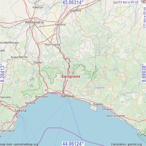
Savignone GPS coordinates[2]
44° 33' 51.66" North, 8° 59' 14.136" East
| Map corner | latitude | longitude |
|---|---|---|
| Upper-left | 45.06314°, | 8.28413° |
| Center: | 44.56435°, | 8.98726° |
| Lower-right: | 44.06124°, | 9.69038° |
| Map W x H: | 111.4×111.4 km | = 69.2×69.2mi |
| max Lat: | 47.04031° ⇑48.1% North |
| Savignone: | 44.56435° |
| min Lat: | ⇓51.9% South 35.50142° |
| min Long | Savignone | max Long |
| 6.69888° | 8.98726° | 18.48682° |
| W 18.6%⇐ | ⇒81.4% E |
Elevation
Elevation of Savignone is 474 m = 1555 ft, and this is 167.3 m = 549 ft above average elevation for this country.
| Max E: |
2085 m = 6841 ft | 23.4% |
| Savignone | 474 m 1555 ft | |
| Avg. | 306.7 m = 1006 ft | |
Min E: |
-4 m = -13 ft | 76.6% |
See also: Italy elevation on elevation.city.
Geographical zone
Savignone is located in North temperate zone (between Tropic of Cancer and the Arctic Circle). Distance of this Northern Tropic circle is 2349.2 km =1459.7 mi to South.| Distance of | km | miles | from Savignone |
|---|---|---|---|
| North Pole | 5052 | 3139.2 | to North |
| Arctic Circle | 2446.1 | 1519.9 | to North |
| Tropic Cancer | 2349.2 | 1459.7 | to South |
| Equator | 4955.1 | 3079 | to South |


Nearby cities:
15 places around Savignone: (largest is in red/bold)
• Borgo Fornari-Pieve
4.9 km =3 mi,  304°
304°
• Busalla
3.4 km =2.1 mi,  281°
281°
• Casella
3.4 km =2.1 mi,  161°
161°
• Crocefieschi
3.4 km =2.1 mi,  57°
57°
• Fraconalto
9.1 km =5.7 mi,  289°
289°
• Isorelle
2 km =1.2 mi, 278°
• Mignanego
7.1 km =4.4 mi,  234°
234°
• Molino Vecchio-Scapitola-Baio
6.5 km =4 mi,  98°
98°
• Montoggio
7.2 km =4.5 mi,  136°
136°
• Pedemonte
8.4 km =5.2 mi,  215°
215°
• Piccarello
9.1 km =5.7 mi,  190°
190°
• Prelo
8.5 km =5.3 mi, 222°
• Ronco Scrivia
6.2 km =3.9 mi,  331°
331°
• Serra Riccò
7.1 km =4.4 mi,  213°
213°
• Vobbia
5.8 km =3.6 mi,  44°
44°
Sources, notices
• [Note1] Compared only with cities in Italy existing in our database
• [Src1] Map data: © OpenStreetMap contributors (CC-BY-SA)
• [Src2] Other city data from geonames.org with taken over terms of usage.
• [Src3] Geographical zone / Annual Mean Temperature by Robert A. Rohde @ Wikipedia
