Isoverde geodata
Isoverde (Liguria) is a populated place; located in Italy in Europe/Rome (GMT+2) time zone. With population of 1,097 people, there are 6304 cities with bigger population in this country. Compared to other cities in Italy, 51.4% of cities are located further ↓South; 83.4% of cities are located further →East and 50% of cities have lower elevation than Isoverde. Note1


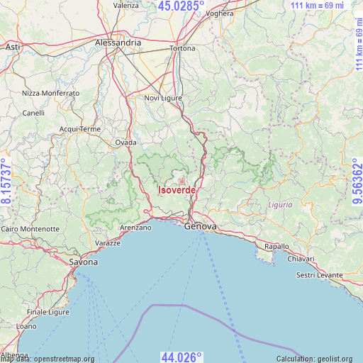
Isoverde GPS coordinates[2]
44° 31' 45.876" North, 8° 51' 37.764" East
| Map corner | latitude | longitude |
|---|---|---|
| Upper-left | 45.0285°, | 8.15737° |
| Center: | 44.52941°, | 8.86049° |
| Lower-right: | 44.026°, | 9.56362° |
| Map W x H: | 111.5×111.5 km | = 69.3×69.3mi |
| max Lat: | 47.04031° ⇑48.6% North |
| Isoverde: | 44.52941° |
| min Lat: | ⇓51.4% South 35.50142° |
| min Long | Isoverde | max Long |
| 6.69888° | 8.86049° | 18.48682° |
| W 16.6%⇐ | ⇒83.4% E |
Elevation
Elevation of Isoverde is 235 m = 771 ft, and this is 71.7 m = 235 ft below average elevation for this country.
| Max E: |
2085 m = 6841 ft | 50% |
| Avg. | 306.7 m = 1006 ft | |
| Isoverde | 235 m = 771 ft | |
Min E: |
-4 m = -13 ft | 50% |
See also: Italy elevation on elevation.city.
Geographical zone
Isoverde is located in North temperate zone (between Tropic of Cancer and the Arctic Circle). Distance of this Northern Tropic circle is 2345.3 km =1457.3 mi to South.| Distance of | km | miles | from Isoverde |
|---|---|---|---|
| North Pole | 5055.9 | 3141.6 | to North |
| Arctic Circle | 2450 | 1522.4 | to North |
| Tropic Cancer | 2345.3 | 1457.3 | to South |
| Equator | 4951.2 | 3076.5 | to South |


Nearby cities:
15 places around Isoverde: (largest is in red/bold)
• Borgo Fornari-Pieve
9 km =5.6 mi,  42°
42°
• Busalla
8.1 km =5 mi,  55°
55°
• Campomorone
2.9 km =1.8 mi,  138°
138°
• Ceranesi
3.7 km =2.3 mi, 135°
• Ferriera-Pontasso
2.3 km =1.4 mi, 144°
• Fraconalto
7 km =4.3 mi,  11°
11°
• Gaiazza
2.9 km =1.8 mi,  161°
161°
• Isorelle
9.1 km =5.7 mi, 62°
• Manesseno
7.8 km =4.8 mi, 136°
• Mignanego
4.3 km =2.7 mi,  92°
92°
• Pedemonte
6 km =3.7 mi,  119°
119°
• Piccarello
9.8 km =6.1 mi, 121°
• Prelo
4.9 km =3 mi, 118°
• Santa Marta
3.8 km =2.4 mi, 137°
• Serra Riccò
6.5 km =4 mi,  108°
108°
Sources, notices
• [Note1] Compared only with cities in Italy existing in our database
• [Src1] Map data: © OpenStreetMap contributors (CC-BY-SA)
• [Src2] Other city data from geonames.org with taken over terms of usage.
• [Src3] Geographical zone / Annual Mean Temperature by Robert A. Rohde @ Wikipedia
