Busalla geodata
Busalla (Liguria) is a seat of a third-order administrative division; located in Italy in Europe/Rome (GMT+2) time zone. With population of 5,216 people, there are 1872 cities with bigger population in this country. Compared to other cities in Italy, 52% of cities are located further ↓South; 82% of cities are located further →East and 67.9% of cities have lower elevation than Busalla. Note1


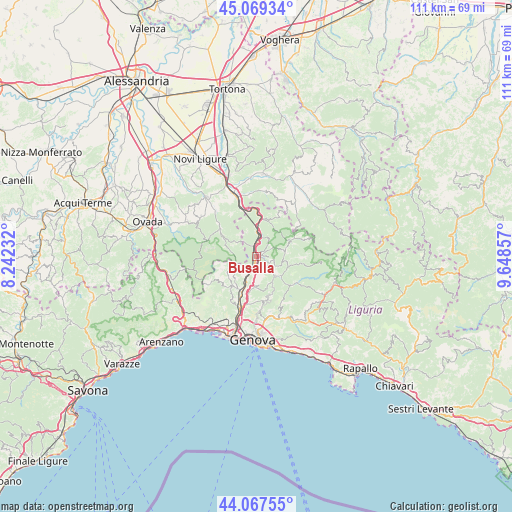
Busalla GPS coordinates[2]
44° 34' 14.16" North, 8° 56' 43.62" East
| Map corner | latitude | longitude |
|---|---|---|
| Upper-left | 45.06934°, | 8.24232° |
| Center: | 44.5706°, | 8.94545° |
| Lower-right: | 44.06755°, | 9.64857° |
| Map W x H: | 111.4×111.4 km | = 69.2×69.2mi |
| max Lat: | 47.04031° ⇑48% North |
| Busalla: | 44.5706° |
| min Lat: | ⇓52% South 35.50142° |
| min Long | Busalla | max Long |
| 6.69888° | 8.94545° | 18.48682° |
| W 18%⇐ | ⇒82% E |
Elevation
Elevation of Busalla is 373 m = 1224 ft, and this is 66.3 m = 218 ft above average elevation for this country.
| Max E: |
2085 m = 6841 ft | 32.1% |
| Busalla | 373 m 1224 ft | |
| Avg. | 306.7 m = 1006 ft | |
Min E: |
-4 m = -13 ft | 67.9% |
See also: Italy elevation on elevation.city.
Geographical zone
Busalla is located in North temperate zone (between Tropic of Cancer and the Arctic Circle). Distance of this Northern Tropic circle is 2349.9 km =1460.2 mi to South.| Distance of | km | miles | from Busalla |
|---|---|---|---|
| North Pole | 5051.3 | 3138.7 | to North |
| Arctic Circle | 2445.4 | 1519.5 | to North |
| Tropic Cancer | 2349.9 | 1460.2 | to South |
| Equator | 4955.8 | 3079.4 | to South |


Nearby cities:
15 places around Busalla: (largest is in red/bold)
• Borgo Fornari-Pieve
2.2 km =1.4 mi,  341°
341°
• Campomorone
8.3 km =5.2 mi,  215°
215°
• Casella
5.9 km =3.7 mi,  131°
131°
• Ceranesi
8.3 km =5.2 mi,  209°
209°
• Crocefieschi
6.3 km =3.9 mi,  79°
79°
• Fraconalto
5.8 km =3.6 mi,  293°
293°
• Isorelle
1.3 km =0.8 mi,  106°
106°
• Isoverde
8.1 km =5 mi,  235°
235°
• Mignanego
5.4 km =3.4 mi, 207°
• Pedemonte
7.7 km =4.8 mi,  191°
191°
• Prelo
7.4 km =4.6 mi,  199°
199°
• Ronco Scrivia
4.8 km =3 mi,  4°
4°
• Savignone
3.4 km =2.1 mi,  101°
101°
• Serra Riccò
6.7 km =4.2 mi, 185°
• Vobbia
8.1 km =5 mi,  65°
65°
Sources, notices
• [Note1] Compared only with cities in Italy existing in our database
• [Src1] Map data: © OpenStreetMap contributors (CC-BY-SA)
• [Src2] Other city data from geonames.org with taken over terms of usage.
• [Src3] Geographical zone / Annual Mean Temperature by Robert A. Rohde @ Wikipedia
