Rock Spring geodata
Rock Spring (Trelawny) is a seat of a second-order administrative division; located in Jamaica in America/Jamaica (GMT-5) time zone. In our database, there are 88 cities with bigger population. Compared to other cities in Jamaica, 74.7% of cities are located further ↓South; 68.1% of cities are located further →East and 87.9% of cities have lower elevation than Rock Spring. Note1


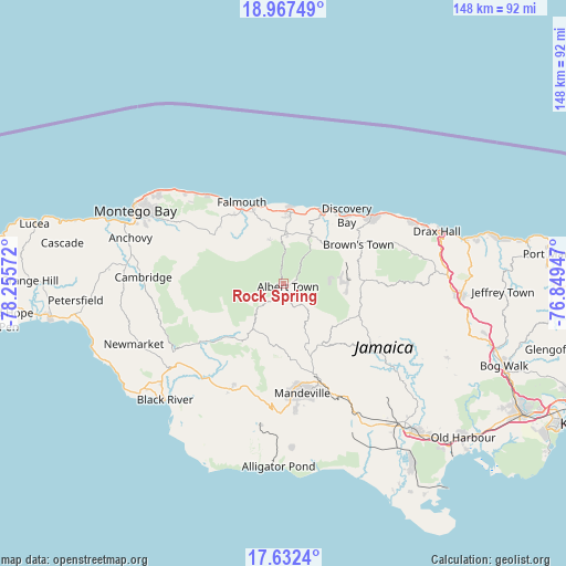
Rock Spring GPS coordinates[2]
18° 18' 4.428" North, 77° 33' 9.324" West
| Map corner | latitude | longitude |
|---|---|---|
| Upper-left | 18.96749°, | -78.25572° |
| Center: | 18.30123°, | -77.55259° |
| Lower-right: | 17.6324°, | -76.84947° |
| Map W x H: | 148.4×148.5 km | = 92.2×92.3mi |
| max Lat: | 18.49358° ⇑25.3% North |
| Rock Spring: | 18.30123° |
| min Lat: | ⇓74.7% South 17.774° |
| min Long | Rock Spring | max Long |
| -78.3481° | -77.55259° | -76.24864° |
| W 31.9%⇐ | ⇒68.1% E |
Elevation
Elevation of Rock Spring is 607 m = 1991 ft, and this is 392.6 m = 1288 ft above average elevation for this country.
| Max E: |
944 m = 3097 ft | 12.1% |
| Rock Spring | 607 m 1991 ft | |
| Avg. | 214.4 m = 703 ft | |
Min E: |
1 m = 3 ft | 87.9% |
See also: Jamaica elevation on elevation.city.
Geographical zone
Rock Spring is located in North Torrid zone (between Equator and Tropic of Cancer). Distance of this Northern Tropic circle is 571 km =354.8 mi to North.| Distance of | km | miles | from Rock Spring |
|---|---|---|---|
| North Pole | 7972.2 | 4953.7 | to North |
| Arctic Circle | 5366.3 | 3334.5 | to North |
| Tropic Cancer | 571 | 354.8 | to North |
| Equator | 2034.9 | 1264.4 | to South |


Nearby cities:
15 places around Rock Spring: (largest is in red/bold)
• Albert Town
1.3 km =0.8 mi,  125°
125°
• Alexandria
21 km =13 mi,  88°
88°
• Balaclava
17.3 km =10.7 mi,  213°
213°
• Coleyville
11.4 km =7.1 mi,  155°
155°
• Discovery Bay
23.8 km =14.8 mi,  42°
42°
• Duncans
18.6 km =11.6 mi,  5°
5°
• Falmouth
24 km =14.9 mi,  333°
333°
• Limit
18.6 km =11.6 mi,  152°
152°
• Maggotty
27.2 km =16.9 mi,  234°
234°
• Maroon Town
26.1 km =16.2 mi,  280°
280°
• Quickstep
10.8 km =6.7 mi,  246°
246°
• Siloah
21.8 km =13.5 mi, 226°
• Ulster Spring
3.7 km =2.3 mi,  65°
65°
• Wakefield
21.7 km =13.5 mi,  304°
304°
• Williamsfield
27.6 km =17.1 mi, 160°
Sources, notices
• [Note1] Compared only with cities in Jamaica existing in our database
• [Src1] Map data: © OpenStreetMap contributors (CC-BY-SA)
• [Src2] Other city data from geonames.org with taken over terms of usage.
• [Src3] Geographical zone / Annual Mean Temperature by Robert A. Rohde @ Wikipedia
