Falmouth geodata
Falmouth (Trelawny) is a seat of a first-order administrative division; located in Jamaica in America/Jamaica (GMT-5) time zone. With population of 7,779 people, there are 23 cities with bigger population in this country. Compared to other cities in Jamaica, 100% of cities are located further ↓South; 74.7% of cities are located further →East and 96.7% of cities have higher elevation than Falmouth. Note1


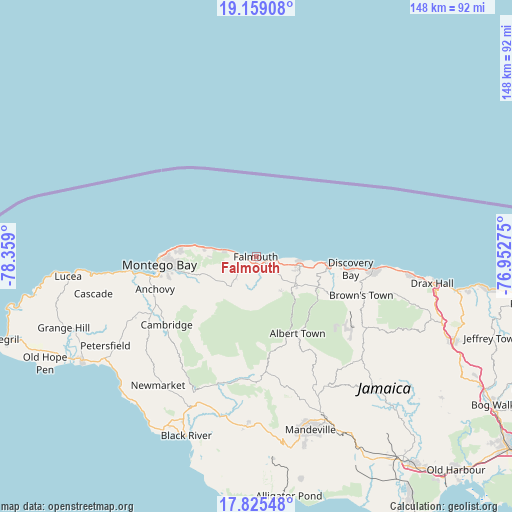
Falmouth GPS coordinates[2]
18° 29' 36.888" North, 77° 39' 21.132" West
| Map corner | latitude | longitude |
|---|---|---|
| Upper-left | 19.15908°, | -78.359° |
| Center: | 18.49358°, | -77.65587° |
| Lower-right: | 17.82548°, | -76.95275° |
| Map W x H: | 148.3×148.3 km | = 92.1×92.1mi |
| max Lat: | 18.49358° ⇑0% North |
| Falmouth: | 18.49358° |
| min Lat: | ⇓100% South 17.774° |
| min Long | Falmouth | max Long |
| -78.3481° | -77.65587° | -76.24864° |
| W 25.3%⇐ | ⇒74.7% E |
Elevation
Elevation of Falmouth is 5 m = 16 ft, and this is 209.4 m = 687 ft below average elevation for this country.
| Max E: |
944 m = 3097 ft | 96.7% |
| Avg. | 214.4 m = 703 ft | |
| Falmouth | 5 m = 16 ft | |
Min E: |
1 m = 3 ft | 3.3% |
See also: Jamaica elevation on elevation.city.
Geographical zone
Falmouth is located in North Torrid zone (between Equator and Tropic of Cancer). Distance of this Northern Tropic circle is 549.6 km =341.5 mi to North.| Distance of | km | miles | from Falmouth |
|---|---|---|---|
| North Pole | 7950.8 | 4940.4 | to North |
| Arctic Circle | 5344.9 | 3321.2 | to North |
| Tropic Cancer | 549.6 | 341.5 | to North |
| Equator | 2056.3 | 1277.7 | to South |


Nearby cities:
15 places around Falmouth: (largest is in red/bold)
• Albert Town
25.2 km =15.7 mi,  151°
151°
• Anchovy
30.5 km =19 mi,  252°
252°
• Balaclava
35.7 km =22.2 mi,  177°
177°
• Cambridge
32.9 km =20.4 mi,  232°
232°
• Coleyville
35.4 km =22 mi, 153°
• Discovery Bay
27.3 km =17 mi,  98°
98°
• Duncans
12.9 km =8 mi, 102°
• Maroon Town
22.2 km =13.8 mi,  221°
221°
• Montego Bay
27.8 km =17.3 mi,  264°
264°
• Quickstep
25.7 km =16 mi, 177°
• Rock Spring
24 km =14.9 mi, 153°
• Runaway Bay
34 km =21.1 mi, 96°
• Siloah
36.6 km =22.7 mi,  187°
187°
• Ulster Spring
24.5 km =15.2 mi,  144°
144°
• Wakefield
11.4 km =7.1 mi, 217°
Sources, notices
• [Note1] Compared only with cities in Jamaica existing in our database
• [Src1] Map data: © OpenStreetMap contributors (CC-BY-SA)
• [Src2] Other city data from geonames.org with taken over terms of usage.
• [Src3] Geographical zone / Annual Mean Temperature by Robert A. Rohde @ Wikipedia
