Coleyville geodata
Coleyville (Manchester) is a populated place; located in Jamaica in America/Jamaica (GMT-5) time zone. With population of 3,860 people, there are 41 cities with bigger population in this country. Compared to other cities in Jamaica, 60.4% of cities are located further ↓South; 63.7% of cities are located further →East and 100% of cities have lower elevation than Coleyville. Note1


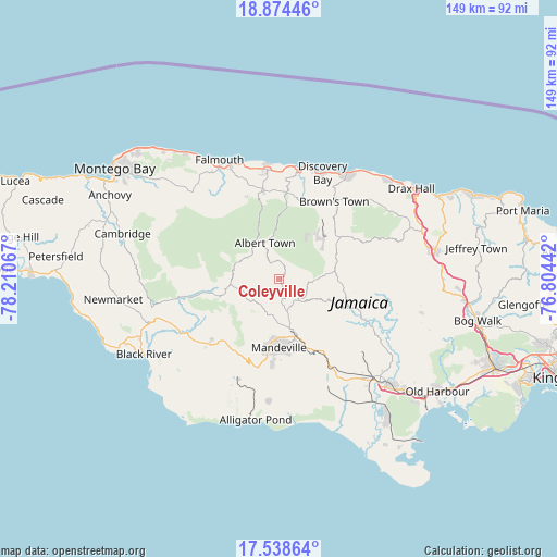
Coleyville GPS coordinates[2]
18° 12' 28.188" North, 77° 30' 27.144" West
| Map corner | latitude | longitude |
|---|---|---|
| Upper-left | 18.87446°, | -78.21067° |
| Center: | 18.20783°, | -77.50754° |
| Lower-right: | 17.53864°, | -76.80442° |
| Map W x H: | 148.5×148.5 km | = 92.3×92.3mi |
| max Lat: | 18.49358° ⇑39.6% North |
| Coleyville: | 18.20783° |
| min Lat: | ⇓60.4% South 17.774° |
| min Long | Coleyville | max Long |
| -78.3481° | -77.50754° | -76.24864° |
| W 36.3%⇐ | ⇒63.7% E |
Elevation
Elevation of Coleyville is 944 m = 3097 ft, and this is 729.6 m = 2394 ft above average elevation for this country.
| Max E: |
944 m = 3097 ft | 0% |
| Coleyville | 944 m 3097 ft | |
| Avg. | 214.4 m = 703 ft | |
Min E: |
1 m = 3 ft | 100% |
See also: Jamaica elevation on elevation.city.
Geographical zone
Coleyville is located in North Torrid zone (between Equator and Tropic of Cancer). Distance of this Northern Tropic circle is 581.4 km =361.3 mi to North.| Distance of | km | miles | from Coleyville |
|---|---|---|---|
| North Pole | 7982.5 | 4960.1 | to North |
| Arctic Circle | 5376.7 | 3340.9 | to North |
| Tropic Cancer | 581.4 | 361.3 | to North |
| Equator | 2024.5 | 1258 | to South |


Nearby cities:
15 places around Coleyville: (largest is in red/bold)
• Albert Town
10.3 km =6.4 mi,  339°
339°
• Alexandria
19.7 km =12.2 mi,  55°
55°
• Balaclava
14.9 km =9.3 mi,  254°
254°
• Kellits
25.6 km =15.9 mi,  101°
101°
• Limit
7.2 km =4.5 mi,  147°
147°
• Maggotty
27.5 km =17.1 mi,  259°
259°
• Mandeville
18.5 km =11.5 mi,  179°
179°
• Mocho
26.5 km =16.5 mi,  134°
134°
• Porus
21.7 km =13.5 mi, 152°
• Quickstep
15.8 km =9.8 mi,  292°
292°
• Rock Spring
11.4 km =7.1 mi, 335°
• Santa Cruz
26.5 km =16.5 mi,  229°
229°
• Siloah
21.2 km =13.2 mi, 257°
• Ulster Spring
12 km =7.5 mi,  353°
353°
• Williamsfield
16.3 km =10.1 mi,  164°
164°
Sources, notices
• [Note1] Compared only with cities in Jamaica existing in our database
• [Src1] Map data: © OpenStreetMap contributors (CC-BY-SA)
• [Src2] Other city data from geonames.org with taken over terms of usage.
• [Src3] Geographical zone / Annual Mean Temperature by Robert A. Rohde @ Wikipedia
