Mocho geodata
Mocho (Clarendon) is a seat of a second-order administrative division; located in Jamaica in America/Jamaica (GMT-5) time zone. In our database, there are 88 cities with bigger population. Compared to other cities in Jamaica, 65.9% of cities are located further ↑North; 54.9% of cities are located further →East and 84.6% of cities have lower elevation than Mocho. Note1


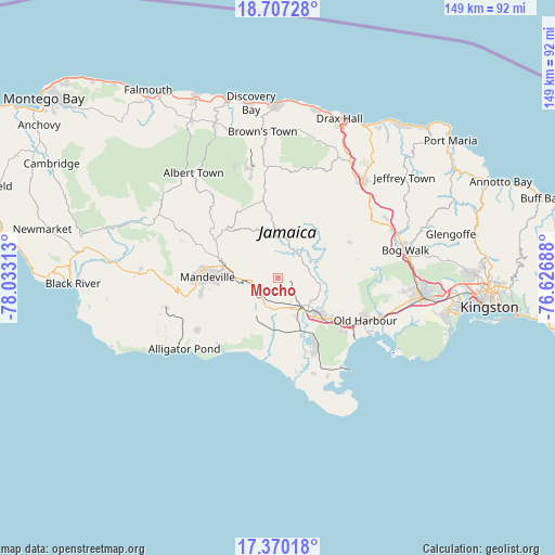
Mocho GPS coordinates[2]
18° 2' 24" North, 77° 19' 48" West
| Map corner | latitude | longitude |
|---|---|---|
| Upper-left | 18.70728°, | -78.03313° |
| Center: | 18.04°, | -77.33° |
| Lower-right: | 17.37018°, | -76.62688° |
| Map W x H: | 148.7×148.7 km | = 92.4×92.4mi |
| max Lat: | 18.49358° ⇑65.9% North |
| Mocho: | 18.04° |
| min Lat: | ⇓34.1% South 17.774° |
| min Long | Mocho | max Long |
| -78.3481° | -77.33° | -76.24864° |
| W 45.1%⇐ | ⇒54.9% E |
Elevation
Elevation of Mocho is 469 m = 1539 ft, and this is 254.6 m = 835 ft above average elevation for this country.
| Max E: |
944 m = 3097 ft | 15.4% |
| Mocho | 469 m 1539 ft | |
| Avg. | 214.4 m = 703 ft | |
Min E: |
1 m = 3 ft | 84.6% |
See also: Jamaica elevation on elevation.city.
Geographical zone
Mocho is located in North Torrid zone (between Equator and Tropic of Cancer). Distance of this Northern Tropic circle is 600.1 km =372.9 mi to North.| Distance of | km | miles | from Mocho |
|---|---|---|---|
| North Pole | 8001.2 | 4971.7 | to North |
| Arctic Circle | 5395.3 | 3352.5 | to North |
| Tropic Cancer | 600.1 | 372.9 | to North |
| Equator | 2005.9 | 1246.4 | to South |


Nearby cities:
15 places around Mocho: (largest is in red/bold)
• Chapelton
8.2 km =5.1 mi,  54°
54°
• Coleyville
26.5 km =16.5 mi,  314°
314°
• Hayes
20.7 km =12.9 mi,  151°
151°
• Kellits
14.9 km =9.3 mi,  24°
24°
• Limit
19.5 km =12.1 mi, 310°
• Lionel Town
27.3 km =17 mi,  159°
159°
• Lluidas Vale
21.5 km =13.4 mi,  63°
63°
• Mandeville
18.7 km =11.6 mi,  270°
270°
• May Pen
12.3 km =7.6 mi,  133°
133°
• Old Harbour
25.8 km =16 mi,  115°
115°
• Old Harbour Bay
28.6 km =17.8 mi, 120°
• Point Hill
24.2 km =15 mi,  76°
76°
• Porus
8.6 km =5.3 mi, 266°
• Race Course
22.8 km =14.2 mi,  167°
167°
• Williamsfield
14.7 km =9.1 mi,  281°
281°
Sources, notices
• [Note1] Compared only with cities in Jamaica existing in our database
• [Src1] Map data: © OpenStreetMap contributors (CC-BY-SA)
• [Src2] Other city data from geonames.org with taken over terms of usage.
• [Src3] Geographical zone / Annual Mean Temperature by Robert A. Rohde @ Wikipedia
