Williamsfield geodata
Williamsfield (Manchester) is a populated place; located in Jamaica in America/Jamaica (GMT-5) time zone. With population of 3,255 people, there are 47 cities with bigger population in this country. Compared to other cities in Jamaica, 60.4% of cities are located further ↑North; 60.4% of cities are located further →East and 81.3% of cities have lower elevation than Williamsfield. Note1


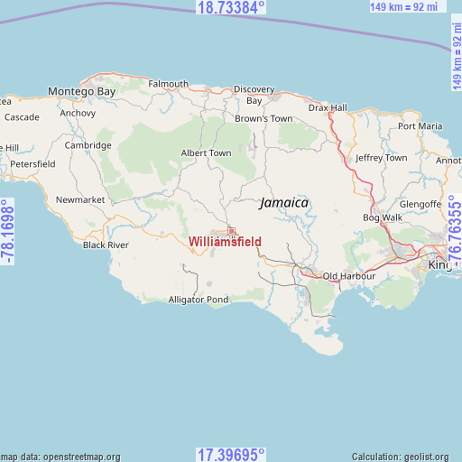
Williamsfield GPS coordinates[2]
18° 4' 0.012" North, 77° 28' 0.012" West
| Map corner | latitude | longitude |
|---|---|---|
| Upper-left | 18.73384°, | -78.1698° |
| Center: | 18.06667°, | -77.46667° |
| Lower-right: | 17.39695°, | -76.76355° |
| Map W x H: | 148.6×148.7 km | = 92.3×92.4mi |
| max Lat: | 18.49358° ⇑60.4% North |
| Williamsfield: | 18.06667° |
| min Lat: | ⇓39.6% South 17.774° |
| min Long | Williamsfield | max Long |
| -78.3481° | -77.46667° | -76.24864° |
| W 39.6%⇐ | ⇒60.4% E |
Elevation
Elevation of Williamsfield is 427 m = 1401 ft, and this is 212.6 m = 698 ft above average elevation for this country.
| Max E: |
944 m = 3097 ft | 18.7% |
| Williamsfield | 427 m 1401 ft | |
| Avg. | 214.4 m = 703 ft | |
Min E: |
1 m = 3 ft | 81.3% |
See also: Jamaica elevation on elevation.city.
Geographical zone
Williamsfield is located in North Torrid zone (between Equator and Tropic of Cancer). Distance of this Northern Tropic circle is 597.1 km =371 mi to North.| Distance of | km | miles | from Williamsfield |
|---|---|---|---|
| North Pole | 7998.2 | 4969.8 | to North |
| Arctic Circle | 5392.3 | 3350.6 | to North |
| Tropic Cancer | 597.1 | 371 | to North |
| Equator | 2008.8 | 1248.2 | to South |


Nearby cities:
15 places around Williamsfield: (largest is in red/bold)
• Albert Town
26.5 km =16.5 mi,  342°
342°
• Alligator Pond
24.4 km =15.2 mi,  205°
205°
• Balaclava
22.1 km =13.7 mi,  302°
302°
• Bull Savanna
23.9 km =14.9 mi, 213°
• Chapelton
21.2 km =13.2 mi,  84°
84°
• Coleyville
16.3 km =10.1 mi, 344°
• Kellits
23.3 km =14.5 mi,  62°
62°
• Limit
9.6 km =6 mi,  357°
357°
• Malvern
27.1 km =16.8 mi,  245°
245°
• Mandeville
5.1 km =3.2 mi,  236°
236°
• May Pen
26 km =16.2 mi,  115°
115°
• Mocho
14.7 km =9.1 mi,  101°
101°
• Nain
18.5 km =11.5 mi,  232°
232°
• Porus
6.8 km =4.2 mi, 120°
• Santa Cruz
24.5 km =15.2 mi,  266°
266°
Sources, notices
• [Note1] Compared only with cities in Jamaica existing in our database
• [Src1] Map data: © OpenStreetMap contributors (CC-BY-SA)
• [Src2] Other city data from geonames.org with taken over terms of usage.
• [Src3] Geographical zone / Annual Mean Temperature by Robert A. Rohde @ Wikipedia
