Limit geodata
Limit (Clarendon) is a populated place; located in Jamaica in America/Jamaica (GMT-5) time zone. With population of 2,321 people, there are 71 cities with bigger population in this country. Compared to other cities in Jamaica, 50.5% of cities are located further ↑North; 61.5% of cities are located further →East and 97.8% of cities have lower elevation than Limit. Note1


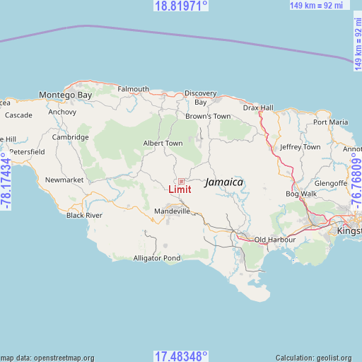
Limit GPS coordinates[2]
18° 9' 10.332" North, 77° 28' 16.356" West
| Map corner | latitude | longitude |
|---|---|---|
| Upper-left | 18.81971°, | -78.17434° |
| Center: | 18.15287°, | -77.47121° |
| Lower-right: | 17.48348°, | -76.76809° |
| Map W x H: | 148.6×148.6 km | = 92.3×92.3mi |
| max Lat: | 18.49358° ⇑50.5% North |
| Limit: | 18.15287° |
| min Lat: | ⇓49.5% South 17.774° |
| min Long | Limit | max Long |
| -78.3481° | -77.47121° | -76.24864° |
| W 38.5%⇐ | ⇒61.5% E |
Elevation
Elevation of Limit is 856 m = 2808 ft, and this is 641.6 m = 2105 ft above average elevation for this country.
| Max E: |
944 m = 3097 ft | 2.2% |
| Limit | 856 m 2808 ft | |
| Avg. | 214.4 m = 703 ft | |
Min E: |
1 m = 3 ft | 97.8% |
See also: Jamaica elevation on elevation.city.
Geographical zone
Limit is located in North Torrid zone (between Equator and Tropic of Cancer). Distance of this Northern Tropic circle is 587.5 km =365.1 mi to North.| Distance of | km | miles | from Limit |
|---|---|---|---|
| North Pole | 7988.7 | 4963.9 | to North |
| Arctic Circle | 5382.8 | 3344.7 | to North |
| Tropic Cancer | 587.5 | 365.1 | to North |
| Equator | 2018.4 | 1254.2 | to South |


Nearby cities:
15 places around Limit: (largest is in red/bold)
• Albert Town
17.4 km =10.8 mi,  334°
334°
• Alexandria
21.2 km =13.2 mi,  35°
35°
• Balaclava
18.4 km =11.4 mi,  276°
276°
• Chapelton
23 km =14.3 mi,  109°
109°
• Coleyville
7.2 km =4.5 mi, 327°
• Kellits
21.2 km =13.2 mi,  87°
87°
• Mandeville
12.9 km =8 mi,  197°
197°
• Mocho
19.5 km =12.1 mi,  130°
130°
• Nain
25.2 km =15.7 mi,  214°
214°
• Porus
14.5 km =9 mi,  154°
154°
• Quickstep
22.1 km =13.7 mi,  303°
303°
• Rock Spring
18.6 km =11.6 mi, 332°
• Siloah
24.6 km =15.3 mi,  273°
273°
• Ulster Spring
18.7 km =11.6 mi,  343°
343°
• Williamsfield
9.6 km =6 mi,  177°
177°
Sources, notices
• [Note1] Compared only with cities in Jamaica existing in our database
• [Src1] Map data: © OpenStreetMap contributors (CC-BY-SA)
• [Src2] Other city data from geonames.org with taken over terms of usage.
• [Src3] Geographical zone / Annual Mean Temperature by Robert A. Rohde @ Wikipedia
