Mandeville geodata
Mandeville (Manchester) is a seat of a first-order administrative division; located in Jamaica in America/Jamaica (GMT-5) time zone. With population of 47,115 people, there are 5 cities with bigger population in this country. Compared to other cities in Jamaica, 64.8% of cities are located further ↑North; 62.6% of cities are located further →East and 90.1% of cities have lower elevation than Mandeville. Note1


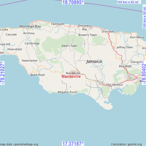
Mandeville GPS coordinates[2]
18° 2' 30.048" North, 77° 30' 25.704" West
| Map corner | latitude | longitude |
|---|---|---|
| Upper-left | 18.70895°, | -78.21027° |
| Center: | 18.04168°, | -77.50714° |
| Lower-right: | 17.37187°, | -76.80402° |
| Map W x H: | 148.7×148.7 km | = 92.4×92.4mi |
| max Lat: | 18.49358° ⇑64.8% North |
| Mandeville: | 18.04168° |
| min Lat: | ⇓35.2% South 17.774° |
| min Long | Mandeville | max Long |
| -78.3481° | -77.50714° | -76.24864° |
| W 37.4%⇐ | ⇒62.6% E |
Elevation
Elevation of Mandeville is 609 m = 1998 ft, and this is 394.6 m = 1295 ft above average elevation for this country.
| Max E: |
944 m = 3097 ft | 9.9% |
| Mandeville | 609 m 1998 ft | |
| Avg. | 214.4 m = 703 ft | |
Min E: |
1 m = 3 ft | 90.1% |
See also: Mandeville elevation on elevation.city.
Geographical zone
Mandeville is located in North Torrid zone (between Equator and Tropic of Cancer). Distance of this Northern Tropic circle is 599.9 km =372.8 mi to North.| Distance of | km | miles | from Mandeville |
|---|---|---|---|
| North Pole | 8001 | 4971.6 | to North |
| Arctic Circle | 5395.1 | 3352.4 | to North |
| Tropic Cancer | 599.9 | 372.8 | to North |
| Equator | 2006 | 1246.5 | to South |


Nearby cities:
15 places around Mandeville: (largest is in red/bold)
• Alligator Pond
20.2 km =12.6 mi,  198°
198°
• Balaclava
20.5 km =12.7 mi,  315°
315°
• Bull Savanna
19.3 km =12 mi,  207°
207°
• Chapelton
25.8 km =16 mi,  79°
79°
• Coleyville
18.5 km =11.5 mi,  359°
359°
• Lacovia
26 km =16.2 mi,  277°
277°
• Limit
12.9 km =8 mi,  17°
17°
• Malvern
22 km =13.7 mi,  247°
247°
• Mocho
18.7 km =11.6 mi,  90°
90°
• Nain
13.4 km =8.3 mi,  230°
230°
• Porus
10.1 km =6.3 mi, 93°
• Santa Cruz
20.3 km =12.6 mi,  273°
273°
• Siloah
25 km =15.5 mi,  303°
303°
• Southfield
24.1 km =15 mi,  224°
224°
• Williamsfield
5.1 km =3.2 mi,  56°
56°
Sources, notices
• [Note1] Compared only with cities in Jamaica existing in our database
• [Src1] Map data: © OpenStreetMap contributors (CC-BY-SA)
• [Src2] Other city data from geonames.org with taken over terms of usage.
• [Src3] Geographical zone / Annual Mean Temperature by Robert A. Rohde @ Wikipedia
