Kafr Abīl geodata
Kafr Abīl (Irbid) is a populated place; located in Jordan in Asia/Amman (GMT+3) time zone. With population of 6,333 people, there are 50 cities with bigger population in this country. Compared to other cities in Jordan, 74.6% of cities are located further ↓South; 81.2% of cities are located further →East and 82.6% of cities have higher elevation than Kafr Abīl. Note1


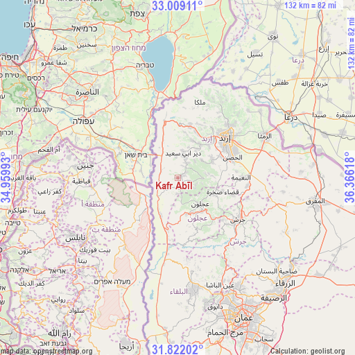
Kafr Abīl GPS coordinates[2]
32° 25' 3.072" North, 35° 39' 46.98" East
| Map corner | latitude | longitude |
|---|---|---|
| Upper-left | 33.00911°, | 34.95993° |
| Center: | 32.41752°, | 35.66305° |
| Lower-right: | 31.82202°, | 36.36618° |
| Map W x H: | 132×132 km | = 82×82mi |
| max Lat: | 33.31405° ⇑25.4% North |
| Kafr Abīl: | 32.41752° |
| min Lat: | ⇓74.6% South 29.40842° |
| min Long | Kafr Abīl | max Long |
| 34.97918° | 35.66305° | 38.70342° |
| W 18.8%⇐ | ⇒81.2% E |
Elevation
Elevation of Kafr Abīl is 440 m = 1444 ft, and this is 245.7 m = 806 ft below average elevation for this country.
| Max E: |
1440 m = 4724 ft | 82.6% |
| Avg. | 685.7 m = 2250 ft | |
| Kafr Abīl | 440 m = 1444 ft | |
Min E: |
-366 m = -1201 ft | 17.4% |
See also: Jordan elevation on elevation.city.
Geographical zone
Kafr Abīl is located in North temperate zone (between Tropic of Cancer and the Arctic Circle). Distance of this Northern Tropic circle is 998.6 km =620.5 mi to South.| Distance of | km | miles | from Kafr Abīl |
|---|---|---|---|
| North Pole | 6402.6 | 3978.4 | to North |
| Arctic Circle | 3796.7 | 2359.2 | to North |
| Tropic Cancer | 998.6 | 620.5 | to South |
| Equator | 3604.5 | 2239.7 | to South |


Nearby cities:
15 places around Kafr Abīl: (largest is in red/bold)
• Al Mazār ash Shamālī
13.9 km =8.6 mi,  64°
64°
• Aţ Ţayyibah
14.9 km =9.3 mi,  20°
20°
• Bayt Īdis
4 km =2.5 mi, 55°
• Dayr Abū Sa‘īd
9.2 km =5.7 mi,  13°
13°
• Dayr Yūsuf
14.7 km =9.1 mi, 58°
• Judita
4.4 km =2.7 mi,  104°
104°
• Kufrinjah
13.8 km =8.6 mi,  164°
164°
• Tibnah
9 km =5.6 mi,  44°
44°
• Waqqāş
14.9 km =9.3 mi,  338°
338°
• Ţabaqat Faḩl
6.3 km =3.9 mi,  306°
306°
• Ḩalāwah
3.7 km =2.3 mi,  182°
182°
• ‘Ajlūn
12.6 km =7.8 mi,  138°
138°
• ‘Anjarah
15.2 km =9.4 mi, 144°
• ‘Ayn Jannah
13.2 km =8.2 mi,  134°
134°
• ‘Irjān
7.1 km =4.4 mi,  111°
111°
Sources, notices
• [Note1] Compared only with cities in Jordan existing in our database
• [Src1] Map data: © OpenStreetMap contributors (CC-BY-SA)
• [Src2] Other city data from geonames.org with taken over terms of usage.
• [Src3] Geographical zone / Annual Mean Temperature by Robert A. Rohde @ Wikipedia
