Aydūn geodata
Aydūn (Irbid) is a section of populated place; located in Jordan in Asia/Amman (GMT+3) time zone. With population of 18,376 people, there are 22 cities with bigger population in this country. Compared to other cities in Jordan, 84.1% of cities are located further ↓South; 62.3% of cities are located further ←West and 60.1% of cities have higher elevation than Aydūn. Note1


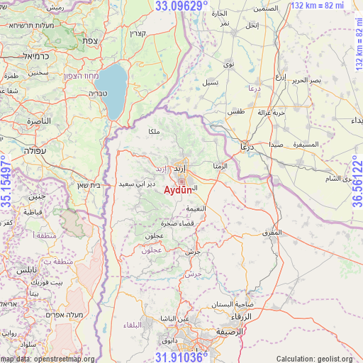
Aydūn GPS coordinates[2]
32° 30' 19.008" North, 35° 51' 29.124" East
| Map corner | latitude | longitude |
|---|---|---|
| Upper-left | 33.09629°, | 35.15497° |
| Center: | 32.50528°, | 35.85809° |
| Lower-right: | 31.91036°, | 36.56122° |
| Map W x H: | 131.9×131.9 km | = 82×82mi |
| max Lat: | 33.31405° ⇑15.9% North |
| Aydūn: | 32.50528° |
| min Lat: | ⇓84.1% South 29.40842° |
| min Long | Aydūn | max Long |
| 34.97918° | 35.85809° | 38.70342° |
| W 62.3%⇐ | ⇒37.7% E |
Elevation
Elevation of Aydūn is 657 m = 2156 ft, and this is 28.7 m = 94 ft below average elevation for this country.
| Max E: |
1440 m = 4724 ft | 60.1% |
| Avg. | 685.7 m = 2250 ft | |
| Aydūn | 657 m = 2156 ft | |
Min E: |
-366 m = -1201 ft | 39.9% |
See also: Jordan elevation on elevation.city.
Geographical zone
Aydūn is located in North temperate zone (between Tropic of Cancer and the Arctic Circle). Distance of this Northern Tropic circle is 1008.3 km =626.5 mi to South.| Distance of | km | miles | from Aydūn |
|---|---|---|---|
| North Pole | 6392.8 | 3972.3 | to North |
| Arctic Circle | 3786.9 | 2353.1 | to North |
| Tropic Cancer | 1008.3 | 626.5 | to South |
| Equator | 3614.2 | 2245.8 | to South |


Nearby cities:
15 places around Aydūn: (largest is in red/bold)
• Al Mazār ash Shamālī
6.9 km =4.3 mi,  235°
235°
• Al Ḩişn
3.4 km =2.1 mi,  133°
133°
• Aţ Ţayyibah
13.8 km =8.6 mi,  287°
287°
• Balīlā
14.8 km =9.2 mi,  149°
149°
• Bayt Yāfā
7 km =4.3 mi, 285°
• Dayr Yūsuf
6.1 km =3.8 mi,  250°
250°
• Irbid
5.6 km =3.5 mi,  352°
352°
• Kitim
8.3 km =5.2 mi, 154°
• Qumaym
13.7 km =8.5 mi,  302°
302°
• Sammā ar Rawsān
15 km =9.3 mi, 348°
• Sāl
8.7 km =5.4 mi,  35°
35°
• Tibnah
12.4 km =7.7 mi, 254°
• Zaḩar
10.1 km =6.3 mi,  312°
312°
• Şakhrah
15 km =9.3 mi,  185°
185°
• Ḩakamā
10.1 km =6.3 mi,  13°
13°
Sources, notices
• [Note1] Compared only with cities in Jordan existing in our database
• [Src1] Map data: © OpenStreetMap contributors (CC-BY-SA)
• [Src2] Other city data from geonames.org with taken over terms of usage.
• [Src3] Geographical zone / Annual Mean Temperature by Robert A. Rohde @ Wikipedia
