Yamaga geodata
Yamaga (Kumamoto) is a seat of a second-order administrative division; located in Japan in Asia/Tokyo (GMT+9) time zone. With population of 32,298 people, there are 526 cities with bigger population in this country. Compared to other cities in Japan, 90.6% of cities are located further ↑North; 89.6% of cities are located further →East and 54.9% of cities have lower elevation than Yamaga. Note1


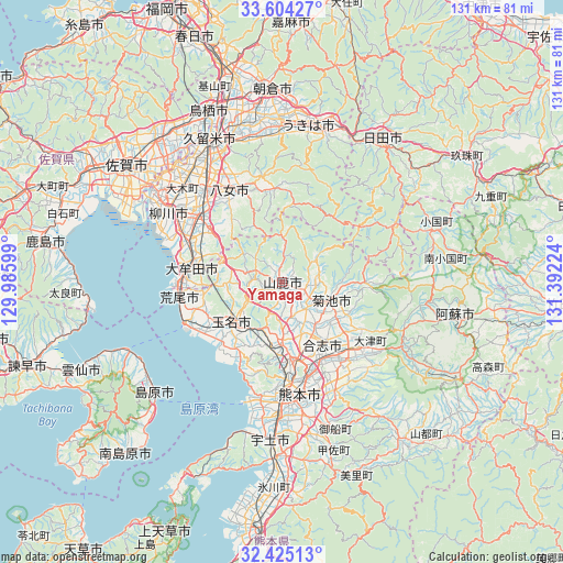
Yamaga GPS coordinates[2]
33° 1' 0.012" North, 130° 41' 20.796" East
| Map corner | latitude | longitude |
|---|---|---|
| Upper-left | 33.60427°, | 129.98599° |
| Center: | 33.01667°, | 130.68911° |
| Lower-right: | 32.42513°, | 131.39224° |
| Map W x H: | 131.1×131.1 km | = 81.5×81.5mi |
| max Lat: | 45.40944° ⇑90.6% North |
| Yamaga: | 33.01667° |
| min Lat: | ⇓9.4% South 24.34478° |
| min Long | Yamaga | max Long |
| 123° | 130.68911° | 145.575° |
| W 10.4%⇐ | ⇒89.6% E |
Elevation
Elevation of Yamaga is 35 m = 115 ft, and this is 49.6 m = 163 ft below average elevation for this country.
| Max E: |
1086 m = 3563 ft | 45.1% |
| Avg. | 84.6 m = 278 ft | |
| Yamaga | 35 m = 115 ft | |
Min E: |
-2 m = -7 ft | 54.9% |
See also: Japan elevation on elevation.city.
Geographical zone
Yamaga is located in North temperate zone (between Tropic of Cancer and the Arctic Circle). Distance of this Northern Tropic circle is 1065.2 km =661.9 mi to South.| Distance of | km | miles | from Yamaga |
|---|---|---|---|
| North Pole | 6336 | 3937 | to North |
| Arctic Circle | 3730.1 | 2317.8 | to North |
| Tropic Cancer | 1065.2 | 661.9 | to South |
| Equator | 3671.1 | 2281.1 | to South |


Nearby cities:
15 places around Yamaga: (largest is in red/bold)
• Arao
23.1 km =14.4 mi,  259°
259°
• Chikugo
27.9 km =17.3 mi,  318°
318°
• Kikuchi
12.5 km =7.8 mi,  107°
107°
• Kumamoto
23.4 km =14.5 mi,  179°
179°
• Kurume
37 km =23 mi,  334°
334°
• Kōshi
16 km =9.9 mi,  149°
149°
• Miyama
21.1 km =13.1 mi,  303°
303°
• Setakamachi-takayanagi
25.5 km =15.8 mi,  305°
305°
• Tamana
13.2 km =8.2 mi,  234°
234°
• Uekimachi-mōno
13 km =8.1 mi, 180°
• Yame
23.8 km =14.8 mi,  350°
350°
• Yanagawa
31.7 km =19.7 mi, 301°
• Ōkawa
36 km =22.4 mi, 305°
• Ōmuta
22.4 km =13.9 mi,  274°
274°
• Ōzu
22.8 km =14.2 mi,  131°
131°
Sources, notices
• [Note1] Compared only with cities in Japan existing in our database
• [Src1] Map data: © OpenStreetMap contributors (CC-BY-SA)
• [Src2] Other city data from geonames.org with taken over terms of usage.
• [Src3] Geographical zone / Annual Mean Temperature by Robert A. Rohde @ Wikipedia
