Tamana geodata
Tamana (Kumamoto) is a seat of a second-order administrative division; located in Japan in Asia/Tokyo (GMT+9) time zone. With population of 45,661 people, there are 403 cities with bigger population in this country. Compared to other cities in Japan, 91.5% of cities are located further ↑North; 91.4% of cities are located further →East and 89.6% of cities have higher elevation than Tamana. Note1


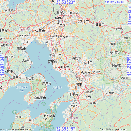
Tamana GPS coordinates[2]
32° 56' 49.776" North, 130° 34' 28.056" East
| Map corner | latitude | longitude |
|---|---|---|
| Upper-left | 33.53523°, | 129.87134° |
| Center: | 32.94716°, | 130.57446° |
| Lower-right: | 32.35515°, | 131.27759° |
| Map W x H: | 131.2×131.2 km | = 81.5×81.5mi |
| max Lat: | 45.40944° ⇑91.5% North |
| Tamana: | 32.94716° |
| min Lat: | ⇓8.5% South 24.34478° |
| min Long | Tamana | max Long |
| 123° | 130.57446° | 145.575° |
| W 8.6%⇐ | ⇒91.4% E |
Elevation
Elevation of Tamana is 5 m = 16 ft, and this is 79.6 m = 261 ft below average elevation for this country.
| Max E: |
1086 m = 3563 ft | 89.6% |
| Avg. | 84.6 m = 278 ft | |
| Tamana | 5 m = 16 ft | |
Min E: |
-2 m = -7 ft | 10.4% |
See also: Tamana elevation on elevation.city.
Geographical zone
Tamana is located in North temperate zone (between Tropic of Cancer and the Arctic Circle). Distance of this Northern Tropic circle is 1057.5 km =657.1 mi to South.| Distance of | km | miles | from Tamana |
|---|---|---|---|
| North Pole | 6343.7 | 3941.8 | to North |
| Arctic Circle | 3737.8 | 2322.6 | to North |
| Tropic Cancer | 1057.5 | 657.1 | to South |
| Equator | 3663.4 | 2276.3 | to South |


Nearby cities:
15 places around Tamana: (largest is in red/bold)
• Arao
12.5 km =7.8 mi,  286°
286°
• Chikugo
29.7 km =18.5 mi,  344°
344°
• Kikuchi
23 km =14.3 mi,  79°
79°
• Kumamoto
19.2 km =11.9 mi,  145°
145°
• Kōshi
19.7 km =12.2 mi,  107°
107°
• Miyama
20.5 km =12.7 mi, 340°
• Setakamachi-takayanagi
24.6 km =15.3 mi, 335°
• Shimabara
26.6 km =16.5 mi,  226°
226°
• Uekimachi-mōno
11.9 km =7.4 mi,  116°
116°
• Uto
30.6 km =19 mi,  163°
163°
• Yamaga
13.2 km =8.2 mi,  54°
54°
• Yame
32 km =19.9 mi,  12°
12°
• Yanagawa
29.3 km =18.2 mi,  326°
326°
• Ōmuta
15.1 km =9.4 mi,  309°
309°
• Ōzu
28.7 km =17.8 mi,  104°
104°
Sources, notices
• [Note1] Compared only with cities in Japan existing in our database
• [Src1] Map data: © OpenStreetMap contributors (CC-BY-SA)
• [Src2] Other city data from geonames.org with taken over terms of usage.
• [Src3] Geographical zone / Annual Mean Temperature by Robert A. Rohde @ Wikipedia
