Arao geodata
Arao (Kumamoto) is a seat of a second-order administrative division; located in Japan in Asia/Tokyo (GMT+9) time zone. In our database, there are 767 cities with bigger population. Compared to other cities in Japan, 91% of cities are located further ↑North; 93.5% of cities are located further →East and 50.1% of cities have higher elevation than Arao. Note1


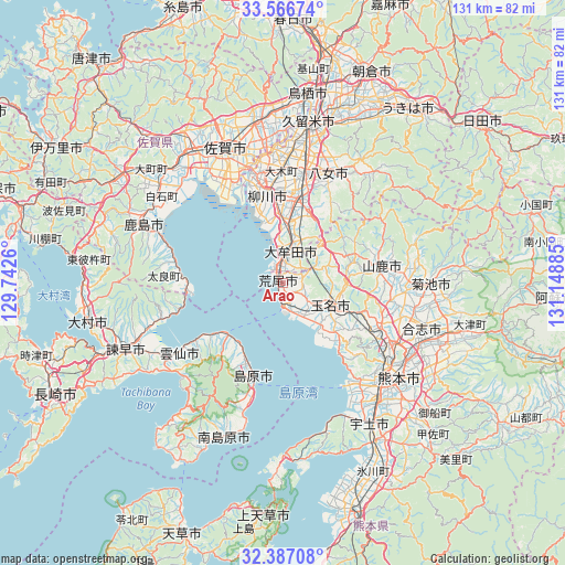
Arao GPS coordinates[2]
32° 58' 43.968" North, 130° 26' 44.592" East
| Map corner | latitude | longitude |
|---|---|---|
| Upper-left | 33.56674°, | 129.7426° |
| Center: | 32.97888°, | 130.44572° |
| Lower-right: | 32.38708°, | 131.14885° |
| Map W x H: | 131.2×131.2 km | = 81.5×81.5mi |
| max Lat: | 45.40944° ⇑91% North |
| Arao: | 32.97888° |
| min Lat: | ⇓9% South 24.34478° |
| min Long | Arao | max Long |
| 123° | 130.44572° | 145.575° |
| W 6.5%⇐ | ⇒93.5% E |
Elevation
Elevation of Arao is 28 m = 92 ft, and this is 56.6 m = 186 ft below average elevation for this country.
| Max E: |
1086 m = 3563 ft | 50.1% |
| Avg. | 84.6 m = 278 ft | |
| Arao | 28 m = 92 ft | |
Min E: |
-2 m = -7 ft | 49.9% |
See also: Japan elevation on elevation.city.
Geographical zone
Arao is located in North temperate zone (between Tropic of Cancer and the Arctic Circle). Distance of this Northern Tropic circle is 1061 km =659.3 mi to South.| Distance of | km | miles | from Arao |
|---|---|---|---|
| North Pole | 6340.2 | 3939.6 | to North |
| Arctic Circle | 3734.3 | 2320.4 | to North |
| Tropic Cancer | 1061 | 659.3 | to South |
| Equator | 3666.9 | 2278.5 | to South |


Nearby cities:
15 places around Arao: (largest is in red/bold)
• Chikugo
25.5 km =15.8 mi,  9°
9°
• Kumamoto
30 km =18.6 mi,  129°
129°
• Kōshi
32.2 km =20 mi,  107°
107°
• Miyama
16.6 km =10.3 mi,  17°
17°
• Saga
31.4 km =19.5 mi,  334°
334°
• Setakamachi-takayanagi
19 km =11.8 mi, 5°
• Shimabara
23 km =14.3 mi,  198°
198°
• Tamana
12.5 km =7.8 mi, 106°
• Uekimachi-mōno
24.3 km =15.1 mi, 111°
• Unzen
29.5 km =18.3 mi,  218°
218°
• Yamaga
23.1 km =14.4 mi,  79°
79°
• Yame
33.5 km =20.8 mi,  34°
34°
• Yanagawa
21.3 km =13.2 mi,  348°
348°
• Ōkawa
26.1 km =16.2 mi, 345°
• Ōmuta
6.1 km =3.8 mi,  3°
3°
Sources, notices
• [Note1] Compared only with cities in Japan existing in our database
• [Src1] Map data: © OpenStreetMap contributors (CC-BY-SA)
• [Src2] Other city data from geonames.org with taken over terms of usage.
• [Src3] Geographical zone / Annual Mean Temperature by Robert A. Rohde @ Wikipedia
