Kumamoto geodata
Kumamoto is a seat of a first-order administrative division; located in Japan in Asia/Tokyo (GMT+9) time zone. With population of 680,423 people, there are 17 cities with bigger population in this country. Compared to other cities in Japan, 92.4% of cities are located further ↑North; 89.5% of cities are located further →East and 76.3% of cities have higher elevation than Kumamoto. Note1


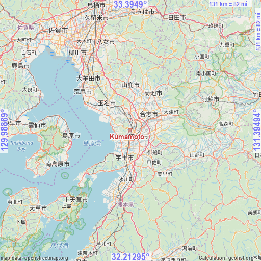
Kumamoto GPS coordinates[2]
32° 48' 21.204" North, 130° 41' 30.516" East
| Map corner | latitude | longitude |
|---|---|---|
| Upper-left | 33.3949°, | 129.98869° |
| Center: | 32.80589°, | 130.69181° |
| Lower-right: | 32.21295°, | 131.39494° |
| Map W x H: | 131.4×131.4 km | = 81.6×81.6mi |
| max Lat: | 45.40944° ⇑92.4% North |
| Kumamoto: | 32.80589° |
| min Lat: | ⇓7.6% South 24.34478° |
| min Long | Kumamoto | max Long |
| 123° | 130.69181° | 145.575° |
| W 10.5%⇐ | ⇒89.5% E |
Elevation
Elevation of Kumamoto is 9 m = 30 ft, and this is 75.6 m = 248 ft below average elevation for this country.
| Max E: |
1086 m = 3563 ft | 76.3% |
| Avg. | 84.6 m = 278 ft | |
| Kumamoto | 9 m = 30 ft | |
Min E: |
-2 m = -7 ft | 23.7% |
See also: Kumamoto elevation on elevation.city.
Geographical zone
Kumamoto is located in North temperate zone (between Tropic of Cancer and the Arctic Circle). Distance of this Northern Tropic circle is 1041.8 km =647.3 mi to South.| Distance of | km | miles | from Kumamoto |
|---|---|---|---|
| North Pole | 6359.4 | 3951.5 | to North |
| Arctic Circle | 3753.5 | 2332.3 | to North |
| Tropic Cancer | 1041.8 | 647.3 | to South |
| Equator | 3647.7 | 2266.6 | to South |


Nearby cities:
15 places around Kumamoto: (largest is in red/bold)
• Arao
30 km =18.6 mi,  309°
309°
• Aso
39.1 km =24.3 mi,  68°
68°
• Honmachi
34.6 km =21.5 mi,  194°
194°
• Kikuchi
22.9 km =14.2 mi,  30°
30°
• Kōshi
12.4 km =7.7 mi,  39°
39°
• Matsubase
17.5 km =10.9 mi, 187°
• Shimabara
30.5 km =19 mi,  265°
265°
• Tamana
19.2 km =11.9 mi,  325°
325°
• Uekimachi-mōno
10.4 km =6.5 mi,  358°
358°
• Uki
20.6 km =12.8 mi, 187°
• Uto
13.8 km =8.6 mi, 189°
• Yamaga
23.4 km =14.5 mi, 359°
• Yatsushiro
27.9 km =17.3 mi, 187°
• Ōmuta
33.9 km =21.1 mi,  318°
318°
• Ōzu
18.7 km =11.6 mi,  63°
63°
Sources, notices
• [Note1] Compared only with cities in Japan existing in our database
• [Src1] Map data: © OpenStreetMap contributors (CC-BY-SA)
• [Src2] Other city data from geonames.org with taken over terms of usage.
• [Src3] Geographical zone / Annual Mean Temperature by Robert A. Rohde @ Wikipedia
