Sakura geodata
Sakura (Tochigi) is a seat of a second-order administrative division; located in Japan in Asia/Tokyo (GMT+9) time zone. In our database, there are 767 cities with bigger population. Compared to other cities in Japan, 80.1% of cities are located further ↓South; 78.3% of cities are located further ←West and 86.9% of cities have lower elevation than Sakura. Note1


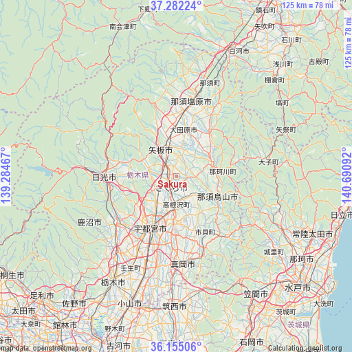
Sakura GPS coordinates[2]
36° 43' 14.592" North, 139° 59' 16.044" East
| Map corner | latitude | longitude |
|---|---|---|
| Upper-left | 37.28224°, | 139.28467° |
| Center: | 36.72072°, | 139.98779° |
| Lower-right: | 36.15506°, | 140.69092° |
| Map W x H: | 125.3×125.3 km | = 77.9×77.9mi |
| max Lat: | 45.40944° ⇑19.9% North |
| Sakura: | 36.72072° |
| min Lat: | ⇓80.1% South 24.34478° |
| min Long | Sakura | max Long |
| 123° | 139.98779° | 145.575° |
| W 78.3%⇐ | ⇒21.7% E |
Elevation
Elevation of Sakura is 190 m = 623 ft, and this is 105.4 m = 346 ft above average elevation for this country.
| Max E: |
1086 m = 3563 ft | 13.1% |
| Sakura | 190 m 623 ft | |
| Avg. | 84.6 m = 278 ft | |
Min E: |
-2 m = -7 ft | 86.9% |
See also: Japan elevation on elevation.city.
Geographical zone
Sakura is located in North temperate zone (between Tropic of Cancer and the Arctic Circle). Distance of this Northern Tropic circle is 1477 km =917.8 mi to South.| Distance of | km | miles | from Sakura |
|---|---|---|---|
| North Pole | 5924.1 | 3681.1 | to North |
| Arctic Circle | 3318.2 | 2061.8 | to North |
| Tropic Cancer | 1477 | 917.8 | to South |
| Equator | 4083 | 2537.1 | to South |


Nearby cities:
15 places around Sakura: (largest is in red/bold)
• Daigo
32.7 km =20.3 mi,  81°
81°
• Imaichi
27.1 km =16.8 mi,  269°
269°
• Kaminokawa
32.6 km =20.3 mi,  191°
191°
• Kanuma
29.6 km =18.4 mi,  230°
230°
• Karasuyama
16.5 km =10.3 mi,  118°
118°
• Kuroiso
27.9 km =17.3 mi,  11°
11°
• Mashiko
30 km =18.6 mi,  160°
160°
• Mooka
32.1 km =19.9 mi,  175°
175°
• Motegi
28.6 km =17.8 mi,  142°
142°
• Nasukarasuyama
17.2 km =10.7 mi, 116°
• Nasushiobara
28.8 km =17.9 mi,  1°
1°
• Ujiie
4.6 km =2.9 mi,  204°
204°
• Utsunomiya
19.5 km =12.1 mi,  208°
208°
• Yaita
10.1 km =6.3 mi,  331°
331°
• Ōtawara
16.7 km =10.4 mi, 14°
Sources, notices
• [Note1] Compared only with cities in Japan existing in our database
• [Src1] Map data: © OpenStreetMap contributors (CC-BY-SA)
• [Src2] Other city data from geonames.org with taken over terms of usage.
• [Src3] Geographical zone / Annual Mean Temperature by Robert A. Rohde @ Wikipedia
