Imaichi geodata
Imaichi (Tochigi) is a populated place; located in Japan in Asia/Tokyo (GMT+9) time zone. With population of 64,323 people, there are 304 cities with bigger population in this country. Compared to other cities in Japan, 79.9% of cities are located further ↓South; 72.9% of cities are located further ←West and 96% of cities have lower elevation than Imaichi. Note1


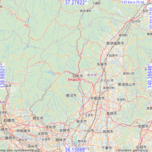
Imaichi GPS coordinates[2]
36° 43' 0.012" North, 139° 40' 59.988" East
| Map corner | latitude | longitude |
|---|---|---|
| Upper-left | 37.27822°, | 138.98021° |
| Center: | 36.71667°, | 139.68333° |
| Lower-right: | 36.15098°, | 140.38646° |
| Map W x H: | 125.3×125.3 km | = 77.9×77.9mi |
| max Lat: | 45.40944° ⇑20.1% North |
| Imaichi: | 36.71667° |
| min Lat: | ⇓79.9% South 24.34478° |
| min Long | Imaichi | max Long |
| 123° | 139.68333° | 145.575° |
| W 72.9%⇐ | ⇒27.1% E |
Elevation
Elevation of Imaichi is 391 m = 1283 ft, and this is 306.4 m = 1005 ft above average elevation for this country.
| Max E: |
1086 m = 3563 ft | 4% |
| Imaichi | 391 m 1283 ft | |
| Avg. | 84.6 m = 278 ft | |
Min E: |
-2 m = -7 ft | 96% |
See also: Imaichi elevation on elevation.city.
Geographical zone
Imaichi is located in North temperate zone (between Tropic of Cancer and the Arctic Circle). Distance of this Northern Tropic circle is 1476.6 km =917.5 mi to South.| Distance of | km | miles | from Imaichi |
|---|---|---|---|
| North Pole | 5924.6 | 3681.4 | to North |
| Arctic Circle | 3318.7 | 2062.1 | to North |
| Tropic Cancer | 1476.6 | 917.5 | to South |
| Equator | 4082.5 | 2536.7 | to South |


Nearby cities:
15 places around Imaichi: (largest is in red/bold)
• Kaminokawa
37.8 km =23.5 mi,  146°
146°
• Kanuma
19.1 km =11.9 mi,  166°
166°
• Karasuyama
42.3 km =26.3 mi,  100°
100°
• Kuroiso
42.9 km =26.7 mi,  49°
49°
• Mibu
34.9 km =21.7 mi,  162°
162°
• Nasushiobara
40.3 km =25 mi,  43°
43°
• Nikkō
7 km =4.3 mi,  301°
301°
• Sakura
27.1 km =16.8 mi,  89°
89°
• Shimotsuke
37.5 km =23.3 mi, 154°
• Tanuma
39.9 km =24.8 mi,  192°
192°
• Tochigi
37.3 km =23.2 mi, 173°
• Ujiie
25.5 km =15.8 mi, 98°
• Utsunomiya
24.4 km =15.2 mi,  133°
133°
• Yaita
24.1 km =15 mi,  67°
67°
• Ōtawara
35.3 km =21.9 mi,  61°
61°
Sources, notices
• [Note1] Compared only with cities in Japan existing in our database
• [Src1] Map data: © OpenStreetMap contributors (CC-BY-SA)
• [Src2] Other city data from geonames.org with taken over terms of usage.
• [Src3] Geographical zone / Annual Mean Temperature by Robert A. Rohde @ Wikipedia
