Kanuma geodata
Kanuma (Tochigi) is a seat of a second-order administrative division; located in Japan in Asia/Tokyo (GMT+9) time zone. With population of 94,903 people, there are 213 cities with bigger population in this country. Compared to other cities in Japan, 77.8% of cities are located further ↓South; 73.9% of cities are located further ←West and 84.1% of cities have lower elevation than Kanuma. Note1


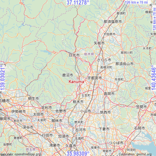
Kanuma GPS coordinates[2]
36° 33' 0" North, 139° 43' 59.988" East
| Map corner | latitude | longitude |
|---|---|---|
| Upper-left | 37.11278°, | 139.03021° |
| Center: | 36.55°, | 139.73333° |
| Lower-right: | 35.98309°, | 140.43646° |
| Map W x H: | 125.6×125.6 km | = 78×78mi |
| max Lat: | 45.40944° ⇑22.2% North |
| Kanuma: | 36.55° |
| min Lat: | ⇓77.8% South 24.34478° |
| min Long | Kanuma | max Long |
| 123° | 139.73333° | 145.575° |
| W 73.9%⇐ | ⇒26.1% E |
Elevation
Elevation of Kanuma is 162 m = 531 ft, and this is 77.4 m = 254 ft above average elevation for this country.
| Max E: |
1086 m = 3563 ft | 15.9% |
| Kanuma | 162 m 531 ft | |
| Avg. | 84.6 m = 278 ft | |
Min E: |
-2 m = -7 ft | 84.1% |
See also: Kanuma elevation on elevation.city.
Geographical zone
Kanuma is located in North temperate zone (between Tropic of Cancer and the Arctic Circle). Distance of this Northern Tropic circle is 1458.1 km =906 mi to South.| Distance of | km | miles | from Kanuma |
|---|---|---|---|
| North Pole | 5943.1 | 3692.9 | to North |
| Arctic Circle | 3337.2 | 2073.6 | to North |
| Tropic Cancer | 1458.1 | 906 | to South |
| Equator | 4064 | 2525.3 | to South |


Nearby cities:
15 places around Kanuma: (largest is in red/bold)
• Imaichi
19.1 km =11.9 mi,  346°
346°
• Kaminokawa
20.9 km =13 mi,  128°
128°
• Mibu
16 km =9.9 mi,  158°
158°
• Mooka
28.5 km =17.7 mi,  117°
117°
• Nikkō
24.6 km =15.3 mi,  334°
334°
• Oyama
28.4 km =17.6 mi,  167°
167°
• Sakura
29.6 km =18.4 mi,  50°
50°
• Sano
29.2 km =18.1 mi,  207°
207°
• Shimotsuke
19.3 km =12 mi,  142°
142°
• Tanuma
24.4 km =15.2 mi, 213°
• Tochigi
18.5 km =11.5 mi,  180°
180°
• Ujiie
25.6 km =15.9 mi, 54°
• Utsunomiya
13.5 km =8.4 mi,  82°
82°
• Yaita
33 km =20.5 mi,  32°
32°
• Yūki
30.9 km =19.2 mi,  154°
154°
Sources, notices
• [Note1] Compared only with cities in Japan existing in our database
• [Src1] Map data: © OpenStreetMap contributors (CC-BY-SA)
• [Src2] Other city data from geonames.org with taken over terms of usage.
• [Src3] Geographical zone / Annual Mean Temperature by Robert A. Rohde @ Wikipedia
