Ujiie geodata
Ujiie (Tochigi) is a populated place; located in Japan in Asia/Tokyo (GMT+9) time zone. With population of 30,366 people, there are 546 cities with bigger population in this country. Compared to other cities in Japan, 79.5% of cities are located further ↓South; 77.5% of cities are located further ←West and 84.4% of cities have lower elevation than Ujiie. Note1


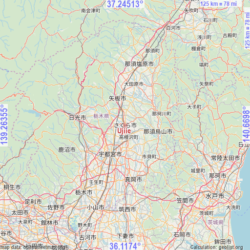
Ujiie GPS coordinates[2]
36° 40' 59.988" North, 139° 58' 0.012" East
| Map corner | latitude | longitude |
|---|---|---|
| Upper-left | 37.24513°, | 139.26355° |
| Center: | 36.68333°, | 139.96667° |
| Lower-right: | 36.1174°, | 140.6698° |
| Map W x H: | 125.4×125.4 km | = 77.9×77.9mi |
| max Lat: | 45.40944° ⇑20.5% North |
| Ujiie: | 36.68333° |
| min Lat: | ⇓79.5% South 24.34478° |
| min Long | Ujiie | max Long |
| 123° | 139.96667° | 145.575° |
| W 77.5%⇐ | ⇒22.5% E |
Elevation
Elevation of Ujiie is 164 m = 538 ft, and this is 79.4 m = 260 ft above average elevation for this country.
| Max E: |
1086 m = 3563 ft | 15.6% |
| Ujiie | 164 m 538 ft | |
| Avg. | 84.6 m = 278 ft | |
Min E: |
-2 m = -7 ft | 84.4% |
See also: Japan elevation on elevation.city.
Geographical zone
Ujiie is located in North temperate zone (between Tropic of Cancer and the Arctic Circle). Distance of this Northern Tropic circle is 1472.9 km =915.2 mi to South.| Distance of | km | miles | from Ujiie |
|---|---|---|---|
| North Pole | 5928.3 | 3683.7 | to North |
| Arctic Circle | 3322.4 | 2064.4 | to North |
| Tropic Cancer | 1472.9 | 915.2 | to South |
| Equator | 4078.8 | 2534.4 | to South |


Nearby cities:
15 places around Ujiie: (largest is in red/bold)
• Imaichi
25.5 km =15.8 mi,  278°
278°
• Kaminokawa
28.2 km =17.5 mi,  189°
189°
• Kanuma
25.6 km =15.9 mi,  234°
234°
• Karasuyama
16.8 km =10.4 mi,  102°
102°
• Kuroiso
32.4 km =20.1 mi,  13°
13°
• Mashiko
26.9 km =16.7 mi,  153°
153°
• Mooka
28.2 km =17.5 mi,  170°
170°
• Motegi
26.8 km =16.7 mi,  133°
133°
• Nasukarasuyama
17.7 km =11 mi, 101°
• Nikkō
32.1 km =19.9 mi, 283°
• Sakura
4.6 km =2.9 mi,  24°
24°
• Shimotsuke
31.3 km =19.4 mi,  196°
196°
• Utsunomiya
15 km =9.3 mi,  209°
209°
• Yaita
13.3 km =8.3 mi,  347°
347°
• Ōtawara
21.2 km =13.2 mi, 16°
Sources, notices
• [Note1] Compared only with cities in Japan existing in our database
• [Src1] Map data: © OpenStreetMap contributors (CC-BY-SA)
• [Src2] Other city data from geonames.org with taken over terms of usage.
• [Src3] Geographical zone / Annual Mean Temperature by Robert A. Rohde @ Wikipedia
