Uji geodata
Uji (Kyoto) is a seat of a second-order administrative division; located in Japan in Asia/Tokyo (GMT+9) time zone. With population of 192,925 people, there are 107 cities with bigger population in this country. Compared to other cities in Japan, 61.2% of cities are located further ↑North; 62.8% of cities are located further →East and 55.4% of cities have higher elevation than Uji. Note1


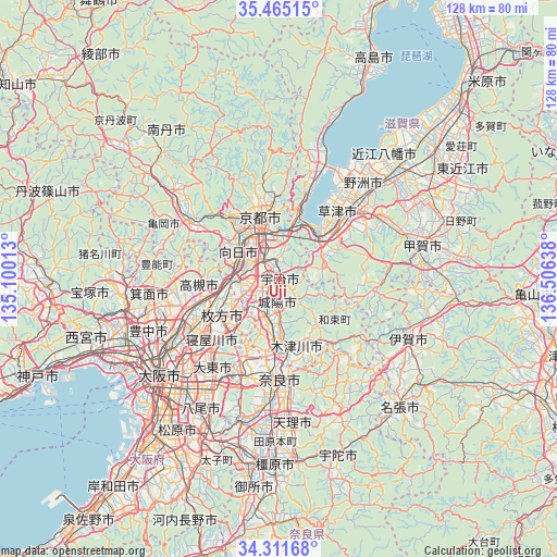
Uji GPS coordinates[2]
34° 53' 25.584" North, 135° 48' 11.7" East
| Map corner | latitude | longitude |
|---|---|---|
| Upper-left | 35.46515°, | 135.10013° |
| Center: | 34.89044°, | 135.80325° |
| Lower-right: | 34.31168°, | 136.50638° |
| Map W x H: | 128.3×128.3 km | = 79.7×79.7mi |
| max Lat: | 45.40944° ⇑61.2% North |
| Uji: | 34.89044° |
| min Lat: | ⇓38.8% South 24.34478° |
| min Long | Uji | max Long |
| 123° | 135.80325° | 145.575° |
| W 37.2%⇐ | ⇒62.8% E |
Elevation
Elevation of Uji is 23 m = 75 ft, and this is 61.6 m = 202 ft below average elevation for this country.
| Max E: |
1086 m = 3563 ft | 55.4% |
| Avg. | 84.6 m = 278 ft | |
| Uji | 23 m = 75 ft | |
Min E: |
-2 m = -7 ft | 44.6% |
See also: Uji elevation on elevation.city.
Geographical zone
Uji is located in North temperate zone (between Tropic of Cancer and the Arctic Circle). Distance of this Northern Tropic circle is 1273.5 km =791.3 mi to South.| Distance of | km | miles | from Uji |
|---|---|---|---|
| North Pole | 6127.6 | 3807.5 | to North |
| Arctic Circle | 3521.7 | 2188.3 | to North |
| Tropic Cancer | 1273.5 | 791.3 | to South |
| Equator | 3879.5 | 2410.6 | to South |


Nearby cities:
15 places around Uji: (largest is in red/bold)
• Arashiyama
18 km =11.2 mi,  320°
320°
• Hirakata
16.5 km =10.3 mi,  238°
238°
• Jōyō
5.2 km =3.2 mi,  177°
177°
• Kamigyō-ku
16 km =9.9 mi,  344°
344°
• Katano
15.2 km =9.4 mi,  224°
224°
• Kizugawa
17.4 km =10.8 mi,  168°
168°
• Kusatsu
20.5 km =12.7 mi,  46°
46°
• Kyoto
15.2 km =9.4 mi, 342°
• Kyōtanabe
10.1 km =6.3 mi,  199°
199°
• Mukō
12.3 km =7.6 mi,  312°
312°
• Nagaoka
11.1 km =6.9 mi,  293°
293°
• Takatsuki
17.6 km =10.9 mi,  254°
254°
• Tanabe
8.3 km =5.2 mi, 204°
• Yawata
9.4 km =5.8 mi,  256°
256°
• Ōtsu
13.5 km =8.4 mi,  25°
25°
Sources, notices
• [Note1] Compared only with cities in Japan existing in our database
• [Src1] Map data: © OpenStreetMap contributors (CC-BY-SA)
• [Src2] Other city data from geonames.org with taken over terms of usage.
• [Src3] Geographical zone / Annual Mean Temperature by Robert A. Rohde @ Wikipedia
