Haibara-akanedai geodata
Haibara-akanedai (Nara) is a populated place; located in Japan in Asia/Tokyo (GMT+9) time zone. With population of 18,472 people, there are 715 cities with bigger population in this country. Compared to other cities in Japan, 71.8% of cities are located further ↑North; 61.9% of cities are located further →East and 94.5% of cities have lower elevation than Haibara-akanedai. Note1


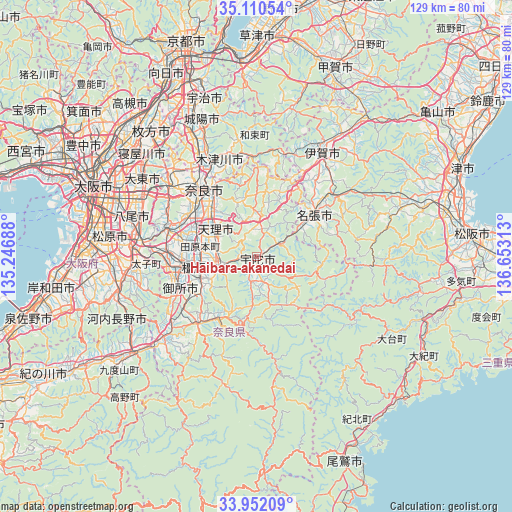
Haibara-akanedai GPS coordinates[2]
34° 31' 59.988" North, 135° 57' 0" East
| Map corner | latitude | longitude |
|---|---|---|
| Upper-left | 35.11054°, | 135.24688° |
| Center: | 34.53333°, | 135.95° |
| Lower-right: | 33.95209°, | 136.65313° |
| Map W x H: | 128.8×128.8 km | = 80×80mi |
| max Lat: | 45.40944° ⇑71.8% North |
| Haibara-akanedai: | 34.53333° |
| min Lat: | ⇓28.2% South 24.34478° |
| min Long | Haibara-akaneda | max Long |
| 123° | 135.95° | 145.575° |
| W 38.1%⇐ | ⇒61.9% E |
Elevation
Elevation of Haibara-akanedai is 345 m = 1132 ft, and this is 260.4 m = 854 ft above average elevation for this country.
| Max E: |
1086 m = 3563 ft | 5.5% |
| Haibara-akanedai | 345 m 1132 ft | |
| Avg. | 84.6 m = 278 ft | |
Min E: |
-2 m = -7 ft | 94.5% |
See also: Japan elevation on elevation.city.
Geographical zone
Haibara-akanedai is located in North temperate zone (between Tropic of Cancer and the Arctic Circle). Distance of this Northern Tropic circle is 1233.8 km =766.6 mi to South.| Distance of | km | miles | from Haibara-akanedai |
|---|---|---|---|
| North Pole | 6167.3 | 3832.2 | to North |
| Arctic Circle | 3561.4 | 2213 | to North |
| Tropic Cancer | 1233.8 | 766.6 | to South |
| Equator | 3839.7 | 2385.9 | to South |


Nearby cities:
15 places around Haibara-akanedai: (largest is in red/bold)
• Gose
21.9 km =13.6 mi,  244°
244°
• Hōryūji
21.3 km =13.2 mi,  294°
294°
• Kashiba
22.1 km =13.7 mi,  270°
270°
• Kashihara-shi
14.6 km =9.1 mi,  259°
259°
• Katsuragi
23.8 km =14.8 mi, 257°
• Kizugawa
24.8 km =15.4 mi,  335°
335°
• Nabari
15.3 km =9.5 mi,  52°
52°
• Nara-shi
21.5 km =13.4 mi,  321°
321°
• Sakurai
9.9 km =6.2 mi,  247°
247°
• Tawaramoto
14.6 km =9.1 mi,  279°
279°
• Tenri
12 km =7.5 mi,  297°
297°
• Yamato-Takada
18.4 km =11.4 mi, 264°
• Yamatokōriyama
18.4 km =11.4 mi, 296°
• Yoshino-chō
17.4 km =10.8 mi,  209°
209°
• Ōuda
7.6 km =4.7 mi,  191°
191°
Sources, notices
• [Note1] Compared only with cities in Japan existing in our database
• [Src1] Map data: © OpenStreetMap contributors (CC-BY-SA)
• [Src2] Other city data from geonames.org with taken over terms of usage.
• [Src3] Geographical zone / Annual Mean Temperature by Robert A. Rohde @ Wikipedia
