Aso geodata
Aso (Kumamoto) is a seat of a second-order administrative division; located in Japan in Asia/Tokyo (GMT+9) time zone. With population of 27,978 people, there are 565 cities with bigger population in this country. Compared to other cities in Japan, 91.6% of cities are located further ↑North; 86.6% of cities are located further →East and 97% of cities have lower elevation than Aso. Note1


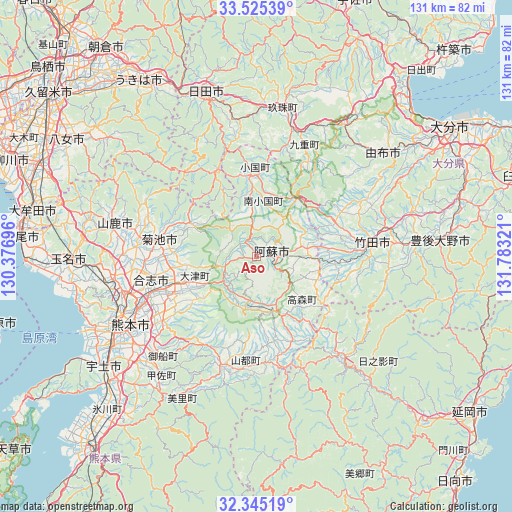
Aso GPS coordinates[2]
32° 56' 14.136" North, 131° 4' 48.288" East
| Map corner | latitude | longitude |
|---|---|---|
| Upper-left | 33.52539°, | 130.37696° |
| Center: | 32.93726°, | 131.08008° |
| Lower-right: | 32.34519°, | 131.78321° |
| Map W x H: | 131.2×131.2 km | = 81.5×81.5mi |
| max Lat: | 45.40944° ⇑91.6% North |
| Aso: | 32.93726° |
| min Lat: | ⇓8.4% South 24.34478° |
| min Long | Aso | max Long |
| 123° | 131.08008° | 145.575° |
| W 13.4%⇐ | ⇒86.6% E |
Elevation
Elevation of Aso is 520 m = 1706 ft, and this is 435.4 m = 1428 ft above average elevation for this country.
| Max E: |
1086 m = 3563 ft | 3% |
| Aso | 520 m 1706 ft | |
| Avg. | 84.6 m = 278 ft | |
Min E: |
-2 m = -7 ft | 97% |
See also: Japan elevation on elevation.city.
Geographical zone
Aso is located in North temperate zone (between Tropic of Cancer and the Arctic Circle). Distance of this Northern Tropic circle is 1056.4 km =656.4 mi to South.| Distance of | km | miles | from Aso |
|---|---|---|---|
| North Pole | 6344.8 | 3942.5 | to North |
| Arctic Circle | 3738.9 | 2323.2 | to North |
| Tropic Cancer | 1056.4 | 656.4 | to South |
| Equator | 3662.3 | 2275.6 | to South |


Nearby cities:
15 places around Aso: (largest is in red/bold)
• Bungo-ōno
42 km =26.1 mi,  84°
84°
• Hita
44.6 km =27.7 mi,  343°
343°
• Kikuchi
25.1 km =15.6 mi,  281°
281°
• Kumamoto
39.1 km =24.3 mi,  248°
248°
• Kōshi
28.8 km =17.9 mi,  260°
260°
• Matsubase
50.1 km =31.1 mi,  230°
230°
• Takedamachi
30 km =18.6 mi, 83°
• Taketa
26.9 km =16.7 mi, 84°
• Tamana
47.2 km =29.3 mi,  271°
271°
• Tsukawaki
38.4 km =23.9 mi,  10°
10°
• Uekimachi-mōno
36.7 km =22.8 mi, 263°
• Uto
47.9 km =29.8 mi, 233°
• Yamaga
37.5 km =23.3 mi, 283°
• Yufu
40 km =24.9 mi,  44°
44°
• Ōzu
20.5 km =12.7 mi, 252°
Sources, notices
• [Note1] Compared only with cities in Japan existing in our database
• [Src1] Map data: © OpenStreetMap contributors (CC-BY-SA)
• [Src2] Other city data from geonames.org with taken over terms of usage.
• [Src3] Geographical zone / Annual Mean Temperature by Robert A. Rohde @ Wikipedia
