Saiki geodata
Saiki (Oita) is a seat of a second-order administrative division; located in Japan in Asia/Tokyo (GMT+9) time zone. With population of 49,065 people, there are 382 cities with bigger population in this country. Compared to other cities in Japan, 91.4% of cities are located further ↑North; 82.8% of cities are located further →East and 95.3% of cities have higher elevation than Saiki. Note1


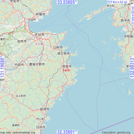
Saiki GPS coordinates[2]
32° 57' 0" North, 131° 54' 0" East
| Map corner | latitude | longitude |
|---|---|---|
| Upper-left | 33.53805°, | 131.19688° |
| Center: | 32.95°, | 131.9° |
| Lower-right: | 32.35801°, | 132.60313° |
| Map W x H: | 131.2×131.2 km | = 81.5×81.5mi |
| max Lat: | 45.40944° ⇑91.4% North |
| Saiki: | 32.95° |
| min Lat: | ⇓8.6% South 24.34478° |
| min Long | Saiki | max Long |
| 123° | 131.9° | 145.575° |
| W 17.2%⇐ | ⇒82.8% E |
Elevation
Elevation of Saiki is 3 m = 10 ft, and this is 81.6 m = 268 ft below average elevation for this country.
| Max E: |
1086 m = 3563 ft | 95.3% |
| Avg. | 84.6 m = 278 ft | |
| Saiki | 3 m = 10 ft | |
Min E: |
-2 m = -7 ft | 4.7% |
See also: Saiki elevation on elevation.city.
Geographical zone
Saiki is located in North temperate zone (between Tropic of Cancer and the Arctic Circle). Distance of this Northern Tropic circle is 1057.8 km =657.3 mi to South.| Distance of | km | miles | from Saiki |
|---|---|---|---|
| North Pole | 6343.4 | 3941.6 | to North |
| Arctic Circle | 3737.5 | 2322.4 | to North |
| Tropic Cancer | 1057.8 | 657.3 | to South |
| Equator | 3663.7 | 2276.5 | to South |


Nearby cities:
15 places around Saiki: (largest is in red/bold)
• Beppu
52.4 km =32.6 mi,  314°
314°
• Bungo-ōno
34.8 km =21.6 mi,  273°
273°
• Hiji
58.1 km =36.1 mi,  323°
323°
• Hyūga
63.4 km =39.4 mi,  202°
202°
• Kitsuki
58.5 km =36.4 mi,  333°
333°
• Kunisaki
69.1 km =42.9 mi,  346°
346°
• Nobeoka
46.2 km =28.7 mi,  208°
208°
• Takedamachi
46.7 km =29 mi, 272°
• Taketa
49.7 km =30.9 mi, 271°
• Tsukumiura
14.2 km =8.8 mi, 348°
• Tsurusaki
38.1 km =23.7 mi, 329°
• Usuki
21.3 km =13.2 mi,  335°
335°
• Uwajima
68.6 km =42.6 mi,  63°
63°
• Yufu
55.8 km =34.7 mi,  299°
299°
• Ōita
42.1 km =26.2 mi, 318°
Sources, notices
• [Note1] Compared only with cities in Japan existing in our database
• [Src1] Map data: © OpenStreetMap contributors (CC-BY-SA)
• [Src2] Other city data from geonames.org with taken over terms of usage.
• [Src3] Geographical zone / Annual Mean Temperature by Robert A. Rohde @ Wikipedia
