Sōja geodata
Sōja (Okayama) is a seat of a second-order administrative division; located in Japan in Asia/Tokyo (GMT+9) time zone. With population of 57,469 people, there are 337 cities with bigger population in this country. Compared to other cities in Japan, 69% of cities are located further ↑North; 76.2% of cities are located further →East and 60.4% of cities have higher elevation than Sōja. Note1


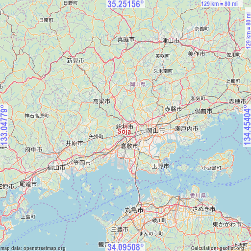
Sōja GPS coordinates[2]
34° 40' 31.224" North, 133° 45' 3.276" East
| Map corner | latitude | longitude |
|---|---|---|
| Upper-left | 35.25156°, | 133.04779° |
| Center: | 34.67534°, | 133.75091° |
| Lower-right: | 34.09508°, | 134.45404° |
| Map W x H: | 128.6×128.6 km | = 79.9×79.9mi |
| max Lat: | 45.40944° ⇑69% North |
| Sōja: | 34.67534° |
| min Lat: | ⇓31% South 24.34478° |
| min Long | Sōja | max Long |
| 123° | 133.75091° | 145.575° |
| W 23.8%⇐ | ⇒76.2% E |
Elevation
Elevation of Sōja is 19 m = 62 ft, and this is 65.6 m = 215 ft below average elevation for this country.
| Max E: |
1086 m = 3563 ft | 60.4% |
| Avg. | 84.6 m = 278 ft | |
| Sōja | 19 m = 62 ft | |
Min E: |
-2 m = -7 ft | 39.6% |
See also: Sōja elevation on elevation.city.
Geographical zone
Sōja is located in North temperate zone (between Tropic of Cancer and the Arctic Circle). Distance of this Northern Tropic circle is 1249.6 km =776.5 mi to South.| Distance of | km | miles | from Sōja |
|---|---|---|---|
| North Pole | 6151.5 | 3822.4 | to North |
| Arctic Circle | 3545.6 | 2203.1 | to North |
| Tropic Cancer | 1249.6 | 776.5 | to South |
| Equator | 3855.5 | 2395.7 | to South |


Nearby cities:
15 places around Sōja: (largest is in red/bold)
• Akaiwa
28.9 km =18 mi,  58°
58°
• Asakuchi
20.7 km =12.9 mi,  220°
220°
• Fukuyama
41.1 km =25.5 mi,  238°
238°
• Ibara
27.3 km =17 mi,  252°
252°
• Kamogatachō-kamogata
21.3 km =13.2 mi, 223°
• Kannabechō-yahiro
33.1 km =20.6 mi, 246°
• Kasaoka
29.4 km =18.3 mi,  230°
230°
• Kurashiki
10.3 km =6.4 mi,  171°
171°
• Marugame
43.7 km =27.2 mi,  176°
176°
• Niimi
43 km =26.7 mi,  322°
322°
• Okayama
16.9 km =10.5 mi,  99°
99°
• Sakaidechō
40 km =24.9 mi, 168°
• Setouchi
35.8 km =22.2 mi,  92°
92°
• Takahashi
17.2 km =10.7 mi,  314°
314°
• Tamano
25 km =15.5 mi,  134°
134°
Sources, notices
• [Note1] Compared only with cities in Japan existing in our database
• [Src1] Map data: © OpenStreetMap contributors (CC-BY-SA)
• [Src2] Other city data from geonames.org with taken over terms of usage.
• [Src3] Geographical zone / Annual Mean Temperature by Robert A. Rohde @ Wikipedia
