Okayama geodata
Okayama is a seat of a first-order administrative division; located in Japan in Asia/Tokyo (GMT+9) time zone. With population of 639,652 people, there are 18 cities with bigger population in this country. Compared to other cities in Japan, 69.7% of cities are located further ↑North; 75.2% of cities are located further →East and 89.6% of cities have higher elevation than Okayama. Note1


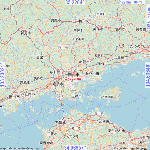
Okayama GPS coordinates[2]
34° 39' 0" North, 133° 55' 59.988" East
| Map corner | latitude | longitude |
|---|---|---|
| Upper-left | 35.2264°, | 133.23021° |
| Center: | 34.65°, | 133.93333° |
| Lower-right: | 34.06957°, | 134.63646° |
| Map W x H: | 128.6×128.6 km | = 79.9×79.9mi |
| max Lat: | 45.40944° ⇑69.7% North |
| Okayama: | 34.65° |
| min Lat: | ⇓30.3% South 24.34478° |
| min Long | Okayama | max Long |
| 123° | 133.93333° | 145.575° |
| W 24.8%⇐ | ⇒75.2% E |
Elevation
Elevation of Okayama is 5 m = 16 ft, and this is 79.6 m = 261 ft below average elevation for this country.
| Max E: |
1086 m = 3563 ft | 89.6% |
| Avg. | 84.6 m = 278 ft | |
| Okayama | 5 m = 16 ft | |
Min E: |
-2 m = -7 ft | 10.4% |
See also: Okayama elevation on elevation.city.
Geographical zone
Okayama is located in North temperate zone (between Tropic of Cancer and the Arctic Circle). Distance of this Northern Tropic circle is 1246.8 km =774.7 mi to South.| Distance of | km | miles | from Okayama |
|---|---|---|---|
| North Pole | 6154.3 | 3824.1 | to North |
| Arctic Circle | 3548.5 | 2204.9 | to North |
| Tropic Cancer | 1246.8 | 774.7 | to South |
| Equator | 3852.7 | 2394 | to South |


Nearby cities:
15 places around Okayama: (largest is in red/bold)
• Akaiwa
19.5 km =12.1 mi,  24°
24°
• Ako
41.8 km =26 mi,  73°
73°
• Asakuchi
32.8 km =20.4 mi,  247°
247°
• Bizen
31.5 km =19.6 mi,  61°
61°
• Kamogatachō-kamogata
33.9 km =21.1 mi, 248°
• Kasaoka
42.4 km =26.3 mi, 247°
• Kurashiki
17 km =10.6 mi,  244°
244°
• Sakaidechō
37.5 km =23.3 mi,  193°
193°
• Setouchi
19.1 km =11.9 mi,  86°
86°
• Shido
42.5 km =26.4 mi,  148°
148°
• Sōja
16.9 km =10.5 mi,  279°
279°
• Takahashi
32.5 km =20.2 mi,  297°
297°
• Takamatsu
36.8 km =22.9 mi,  163°
163°
• Tamano
14.8 km =9.2 mi,  175°
175°
• Tonoshō
28.7 km =17.8 mi,  130°
130°
Sources, notices
• [Note1] Compared only with cities in Japan existing in our database
• [Src1] Map data: © OpenStreetMap contributors (CC-BY-SA)
• [Src2] Other city data from geonames.org with taken over terms of usage.
• [Src3] Geographical zone / Annual Mean Temperature by Robert A. Rohde @ Wikipedia
