Akaiwa geodata
Akaiwa (Okayama) is a seat of a second-order administrative division; located in Japan in Asia/Tokyo (GMT+9) time zone. In our database, there are 767 cities with bigger population. Compared to other cities in Japan, 64.1% of cities are located further ↑North; 75% of cities are located further →East and 60.8% of cities have lower elevation than Akaiwa. Note1


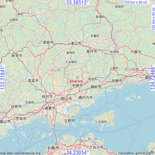
Akaiwa GPS coordinates[2]
34° 48' 35.496" North, 134° 1' 17.508" East
| Map corner | latitude | longitude |
|---|---|---|
| Upper-left | 35.38513°, | 133.31841° |
| Center: | 34.80986°, | 134.02153° |
| Lower-right: | 34.23054°, | 134.72466° |
| Map W x H: | 128.4×128.4 km | = 79.8×79.8mi |
| max Lat: | 45.40944° ⇑64.1% North |
| Akaiwa: | 34.80986° |
| min Lat: | ⇓35.9% South 24.34478° |
| min Long | Akaiwa | max Long |
| 123° | 134.02153° | 145.575° |
| W 25%⇐ | ⇒75% E |
Elevation
Elevation of Akaiwa is 47 m = 154 ft, and this is 37.6 m = 123 ft below average elevation for this country.
| Max E: |
1086 m = 3563 ft | 39.2% |
| Avg. | 84.6 m = 278 ft | |
| Akaiwa | 47 m = 154 ft | |
Min E: |
-2 m = -7 ft | 60.8% |
See also: Japan elevation on elevation.city.
Geographical zone
Akaiwa is located in North temperate zone (between Tropic of Cancer and the Arctic Circle). Distance of this Northern Tropic circle is 1264.6 km =785.8 mi to South.| Distance of | km | miles | from Akaiwa |
|---|---|---|---|
| North Pole | 6136.6 | 3813.1 | to North |
| Arctic Circle | 3530.7 | 2193.9 | to North |
| Tropic Cancer | 1264.6 | 785.8 | to South |
| Equator | 3870.5 | 2405 | to South |


Nearby cities:
15 places around Akaiwa: (largest is in red/bold)
• Aioi
40.8 km =25.4 mi,  90°
90°
• Ako
32.3 km =20.1 mi,  99°
99°
• Bizen
19.7 km =12.2 mi, 97°
• Kariya
34 km =21.1 mi, 101°
• Kurashiki
34.3 km =21.3 mi,  222°
222°
• Maniwa
42.9 km =26.7 mi,  320°
320°
• Mimasaka
31.7 km =19.7 mi,  35°
35°
• Okayama
19.5 km =12.1 mi,  204°
204°
• Setouchi
20.1 km =12.5 mi,  146°
146°
• Sōja
28.9 km =18 mi,  238°
238°
• Takahashi
37.1 km =23.1 mi,  265°
265°
• Tamano
33.2 km =20.6 mi,  192°
192°
• Tatsuno
47.7 km =29.6 mi, 87°
• Tonoshō
39.1 km =24.3 mi,  159°
159°
• Tsuyama
27 km =16.8 mi,  355°
355°
Sources, notices
• [Note1] Compared only with cities in Japan existing in our database
• [Src1] Map data: © OpenStreetMap contributors (CC-BY-SA)
• [Src2] Other city data from geonames.org with taken over terms of usage.
• [Src3] Geographical zone / Annual Mean Temperature by Robert A. Rohde @ Wikipedia
