Gujō geodata
Gujō (Gifu) is a seat of a second-order administrative division; located in Japan in Asia/Tokyo (GMT+9) time zone. With population of 46,918 people, there are 394 cities with bigger population in this country. Compared to other cities in Japan, 60.5% of cities are located further ↓South; 52.4% of cities are located further →East and 93.5% of cities have lower elevation than Gujō. Note1


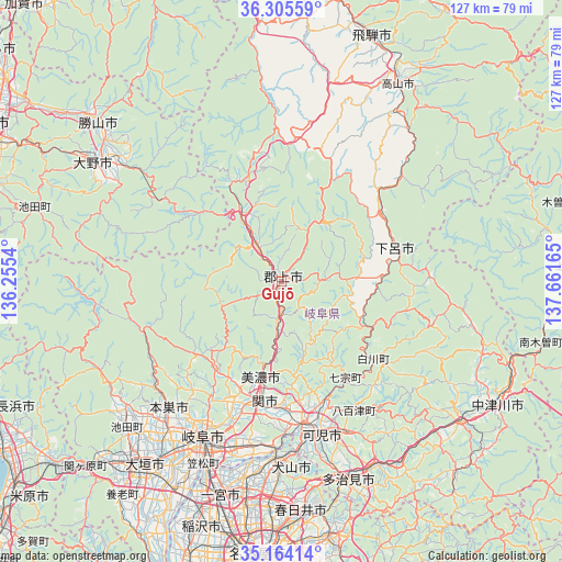
Gujō GPS coordinates[2]
35° 44' 12.876" North, 136° 57' 30.672" East
| Map corner | latitude | longitude |
|---|---|---|
| Upper-left | 36.30559°, | 136.2554° |
| Center: | 35.73691°, | 136.95852° |
| Lower-right: | 35.16414°, | 137.66165° |
| Map W x H: | 126.9×126.9 km | = 78.9×78.9mi |
| max Lat: | 45.40944° ⇑39.5% North |
| Gujō: | 35.73691° |
| min Lat: | ⇓60.5% South 24.34478° |
| min Long | Gujō | max Long |
| 123° | 136.95852° | 145.575° |
| W 47.6%⇐ | ⇒52.4% E |
Elevation
Elevation of Gujō is 314 m = 1030 ft, and this is 229.4 m = 753 ft above average elevation for this country.
| Max E: |
1086 m = 3563 ft | 6.5% |
| Gujō | 314 m 1030 ft | |
| Avg. | 84.6 m = 278 ft | |
Min E: |
-2 m = -7 ft | 93.5% |
See also: Gujō elevation on elevation.city.
Geographical zone
Gujō is located in North temperate zone (between Tropic of Cancer and the Arctic Circle). Distance of this Northern Tropic circle is 1367.7 km =849.8 mi to South.| Distance of | km | miles | from Gujō |
|---|---|---|---|
| North Pole | 6033.5 | 3749 | to North |
| Arctic Circle | 3427.6 | 2129.8 | to North |
| Tropic Cancer | 1367.7 | 849.8 | to South |
| Equator | 3973.6 | 2469.1 | to South |


Nearby cities:
15 places around Gujō: (largest is in red/bold)
• Gero
25.8 km =16 mi,  74°
74°
• Gifu-shi
39.2 km =24.4 mi,  207°
207°
• Inuyama
39.7 km =24.7 mi,  182°
182°
• Kakamigahara
36.6 km =22.7 mi,  193°
193°
• Kani
38 km =23.6 mi,  166°
166°
• Kasamatsuchō
44.7 km =27.8 mi,  202°
202°
• Kuroda
45.8 km =28.5 mi, 200°
• Kōnan
45.8 km =28.5 mi, 190°
• Mino
22.9 km =14.2 mi, 189°
• Minokamo
28.9 km =18 mi, 168°
• Mitake
39 km =24.2 mi,  156°
156°
• Motosu
32.7 km =20.3 mi,  253°
253°
• Motosu
38.1 km =23.7 mi,  222°
222°
• Sekimachi
28.4 km =17.6 mi, 187°
• Yamagata
24.9 km =15.5 mi,  226°
226°
Sources, notices
• [Note1] Compared only with cities in Japan existing in our database
• [Src1] Map data: © OpenStreetMap contributors (CC-BY-SA)
• [Src2] Other city data from geonames.org with taken over terms of usage.
• [Src3] Geographical zone / Annual Mean Temperature by Robert A. Rohde @ Wikipedia
