Ogawa geodata
Ogawa (Saitama) is a populated place; located in Japan in Asia/Tokyo (GMT+9) time zone. With population of 37,443 people, there are 478 cities with bigger population in this country. Compared to other cities in Japan, 68.6% of cities are located further ↓South; 63.9% of cities are located further ←West and 73.5% of cities have lower elevation than Ogawa. Note1


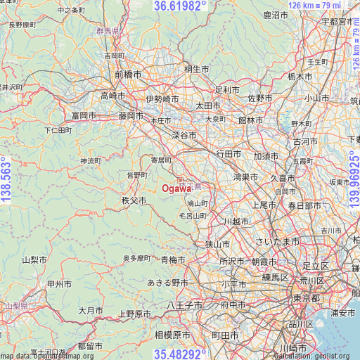
Ogawa GPS coordinates[2]
36° 3' 12.312" North, 139° 15' 58.032" East
| Map corner | latitude | longitude |
|---|---|---|
| Upper-left | 36.61982°, | 138.563° |
| Center: | 36.05342°, | 139.26612° |
| Lower-right: | 35.48292°, | 139.96925° |
| Map W x H: | 126.4×126.4 km | = 78.5×78.5mi |
| max Lat: | 45.40944° ⇑31.4% North |
| Ogawa: | 36.05342° |
| min Lat: | ⇓68.6% South 24.34478° |
| min Long | Ogawa | max Long |
| 123° | 139.26612° | 145.575° |
| W 63.9%⇐ | ⇒36.1% E |
Elevation
Elevation of Ogawa is 90 m = 295 ft, and this is 5.4 m = 18 ft above average elevation for this country.
| Max E: |
1086 m = 3563 ft | 26.5% |
| Ogawa | 90 m 295 ft | |
| Avg. | 84.6 m = 278 ft | |
Min E: |
-2 m = -7 ft | 73.5% |
See also: Japan elevation on elevation.city.
Geographical zone
Ogawa is located in North temperate zone (between Tropic of Cancer and the Arctic Circle). Distance of this Northern Tropic circle is 1402.8 km =871.7 mi to South.| Distance of | km | miles | from Ogawa |
|---|---|---|---|
| North Pole | 5998.3 | 3727.2 | to North |
| Arctic Circle | 3392.4 | 2107.9 | to North |
| Tropic Cancer | 1402.8 | 871.7 | to South |
| Equator | 4008.8 | 2491 | to South |


Nearby cities:
15 places around Ogawa: (largest is in red/bold)
• Chichibu
18.5 km =11.5 mi,  247°
247°
• Fukaya
13.8 km =8.6 mi,  357°
357°
• Fukayachō
16.4 km =10.2 mi,  5°
5°
• Fukiage-fujimi
17.3 km =10.7 mi,  72°
72°
• Gyōda
20 km =12.4 mi,  60°
60°
• Hidaka
17.5 km =10.9 mi,  150°
150°
• Higashi-Matsuyama
13.7 km =8.5 mi,  99°
99°
• Honjō
21.6 km =13.4 mi,  341°
341°
• Kodamachō-kodamaminami
19 km =11.8 mi,  320°
320°
• Kumagaya
14.4 km =8.9 mi,  50°
50°
• Menuma
21.5 km =13.4 mi,  28°
28°
• Morohongō
13.6 km =8.5 mi,  165°
165°
• Sakado
15.4 km =9.6 mi,  134°
134°
• Tsurugashima
16.1 km =10 mi, 130°
• Yorii
9.5 km =5.9 mi, 316°
Sources, notices
• [Note1] Compared only with cities in Japan existing in our database
• [Src1] Map data: © OpenStreetMap contributors (CC-BY-SA)
• [Src2] Other city data from geonames.org with taken over terms of usage.
• [Src3] Geographical zone / Annual Mean Temperature by Robert A. Rohde @ Wikipedia
