Bandō geodata
Bandō (Ibaraki) is a seat of a second-order administrative division; located in Japan in Asia/Tokyo (GMT+9) time zone. In our database, there are 767 cities with bigger population. Compared to other cities in Japan, 69.3% of cities are located further ↓South; 75.7% of cities are located further ←West and 65.3% of cities have higher elevation than Bandō. Note1


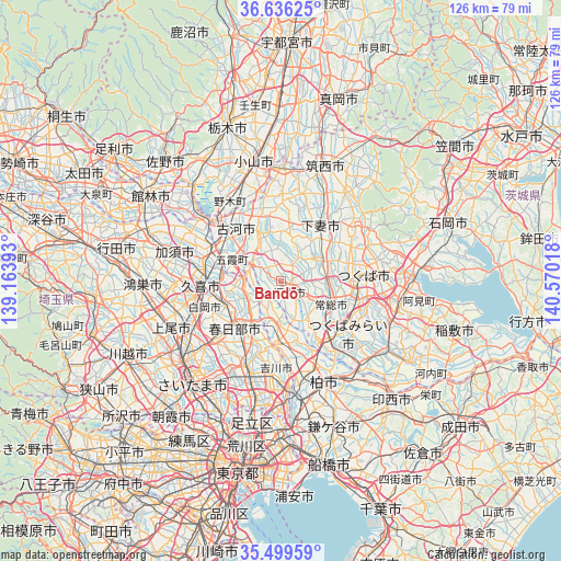
Bandō GPS coordinates[2]
36° 4' 11.892" North, 139° 52' 1.38" East
| Map corner | latitude | longitude |
|---|---|---|
| Upper-left | 36.63625°, | 139.16393° |
| Center: | 36.06997°, | 139.86705° |
| Lower-right: | 35.49959°, | 140.57018° |
| Map W x H: | 126.4×126.4 km | = 78.5×78.5mi |
| max Lat: | 45.40944° ⇑30.7% North |
| Bandō: | 36.06997° |
| min Lat: | ⇓69.3% South 24.34478° |
| min Long | Bandō | max Long |
| 123° | 139.86705° | 145.575° |
| W 75.7%⇐ | ⇒24.3% E |
Elevation
Elevation of Bandō is 15 m = 49 ft, and this is 69.6 m = 228 ft below average elevation for this country.
| Max E: |
1086 m = 3563 ft | 65.3% |
| Avg. | 84.6 m = 278 ft | |
| Bandō | 15 m = 49 ft | |
Min E: |
-2 m = -7 ft | 34.7% |
See also: Japan elevation on elevation.city.
Geographical zone
Bandō is located in North temperate zone (between Tropic of Cancer and the Arctic Circle). Distance of this Northern Tropic circle is 1404.7 km =872.8 mi to South.| Distance of | km | miles | from Bandō |
|---|---|---|---|
| North Pole | 5996.5 | 3726.1 | to North |
| Arctic Circle | 3390.6 | 2106.8 | to North |
| Tropic Cancer | 1404.7 | 872.8 | to South |
| Equator | 4010.6 | 2492.1 | to South |


Nearby cities:
15 places around Bandō: (largest is in red/bold)
• Ishige
10.3 km =6.4 mi,  59°
59°
• Iwai
3.7 km =2.3 mi,  126°
126°
• Jōsō
9.3 km =5.8 mi,  114°
114°
• Kasukabe
14.3 km =8.9 mi,  227°
227°
• Koga
18.5 km =11.5 mi,  313°
313°
• Kukichūō
17.3 km =10.7 mi,  269°
269°
• Kurihashi
16.6 km =10.3 mi,  295°
295°
• Mitsukaidō
12 km =7.5 mi,  119°
119°
• Moriya
19.3 km =12 mi,  141°
141°
• Noda
13.5 km =8.4 mi,  179°
179°
• Sakai
6.9 km =4.3 mi, 298°
• Satte
12.7 km =7.9 mi, 271°
• Shimo-tsuma
15.5 km =9.6 mi,  35°
35°
• Sugito
13.4 km =8.3 mi,  251°
251°
• Tsukubamirai
16 km =9.9 mi, 126°
Sources, notices
• [Note1] Compared only with cities in Japan existing in our database
• [Src1] Map data: © OpenStreetMap contributors (CC-BY-SA)
• [Src2] Other city data from geonames.org with taken over terms of usage.
• [Src3] Geographical zone / Annual Mean Temperature by Robert A. Rohde @ Wikipedia
