Itoigawa geodata
Itoigawa (Niigata) is a seat of a second-order administrative division; located in Japan in Asia/Tokyo (GMT+9) time zone. With population of 30,865 people, there are 540 cities with bigger population in this country. Compared to other cities in Japan, 82.2% of cities are located further ↓South; 52.4% of cities are located further ←West and 65.3% of cities have higher elevation than Itoigawa. Note1


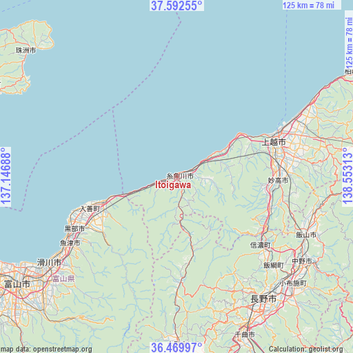
Itoigawa GPS coordinates[2]
37° 1' 59.988" North, 137° 51' 0" East
| Map corner | latitude | longitude |
|---|---|---|
| Upper-left | 37.59255°, | 137.14688° |
| Center: | 37.03333°, | 137.85° |
| Lower-right: | 36.46997°, | 138.55313° |
| Map W x H: | 124.8×124.8 km | = 77.5×77.5mi |
| max Lat: | 45.40944° ⇑17.8% North |
| Itoigawa: | 37.03333° |
| min Lat: | ⇓82.2% South 24.34478° |
| min Long | Itoigawa | max Long |
| 123° | 137.85° | 145.575° |
| W 52.4%⇐ | ⇒47.6% E |
Elevation
Elevation of Itoigawa is 15 m = 49 ft, and this is 69.6 m = 228 ft below average elevation for this country.
| Max E: |
1086 m = 3563 ft | 65.3% |
| Avg. | 84.6 m = 278 ft | |
| Itoigawa | 15 m = 49 ft | |
Min E: |
-2 m = -7 ft | 34.7% |
See also: Japan elevation on elevation.city.
Geographical zone
Itoigawa is located in North temperate zone (between Tropic of Cancer and the Arctic Circle). Distance of this Northern Tropic circle is 1511.8 km =939.4 mi to South.| Distance of | km | miles | from Itoigawa |
|---|---|---|---|
| North Pole | 5889.3 | 3659.4 | to North |
| Arctic Circle | 3283.5 | 2040.3 | to North |
| Tropic Cancer | 1511.8 | 939.4 | to South |
| Equator | 4117.7 | 2558.6 | to South |


Nearby cities:
15 places around Itoigawa: (largest is in red/bold)
• Arai
33.6 km =20.9 mi,  96°
96°
• Chikuma
60.2 km =37.4 mi,  159°
159°
• Hakuba
37.3 km =23.2 mi,  178°
178°
• Iiyama
50.2 km =31.2 mi,  113°
113°
• Jōetsu
36.6 km =22.7 mi,  69°
69°
• Kamiichi
56.8 km =35.3 mi,  229°
229°
• Kurobe-shi
38.5 km =23.9 mi,  247°
247°
• Myoko
37.6 km =23.4 mi,  93°
93°
• Nagano
51.9 km =32.2 mi,  145°
145°
• Nakano
55.7 km =34.6 mi,  124°
124°
• Namerikawa
53 km =32.9 mi, 234°
• Nyūzen
32.8 km =20.4 mi, 251°
• Suzaka
59.5 km =37 mi,  135°
135°
• Uozu
47.7 km =29.6 mi,  237°
237°
• Ōmachi
59.3 km =36.8 mi, 178°
Sources, notices
• [Note1] Compared only with cities in Japan existing in our database
• [Src1] Map data: © OpenStreetMap contributors (CC-BY-SA)
• [Src2] Other city data from geonames.org with taken over terms of usage.
• [Src3] Geographical zone / Annual Mean Temperature by Robert A. Rohde @ Wikipedia
