Nagaoka geodata
Nagaoka (Kyoto) is a seat of a second-order administrative division; located in Japan in Asia/Tokyo (GMT+9) time zone. In our database, there are 767 cities with bigger population. Compared to other cities in Japan, 60.6% of cities are located further ↑North; 64.5% of cities are located further →East and 51.7% of cities have lower elevation than Nagaoka. Note1


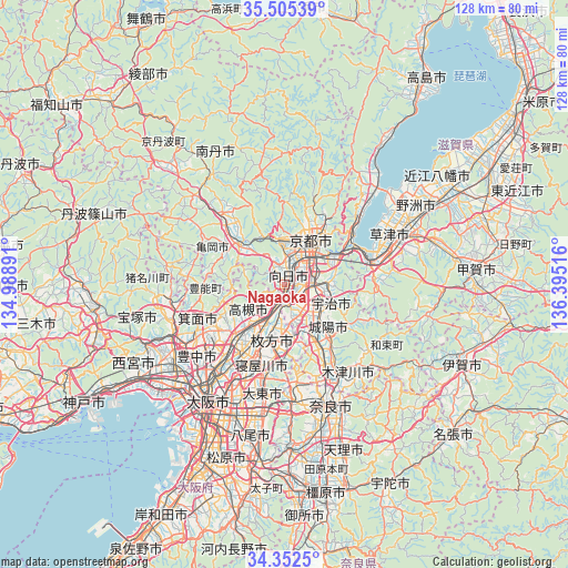
Nagaoka GPS coordinates[2]
34° 55' 51.492" North, 135° 41' 31.308" East
| Map corner | latitude | longitude |
|---|---|---|
| Upper-left | 35.50539°, | 134.98891° |
| Center: | 34.93097°, | 135.69203° |
| Lower-right: | 34.3525°, | 136.39516° |
| Map W x H: | 128.2×128.2 km | = 79.7×79.7mi |
| max Lat: | 45.40944° ⇑60.6% North |
| Nagaoka: | 34.93097° |
| min Lat: | ⇓39.4% South 24.34478° |
| min Long | Nagaoka | max Long |
| 123° | 135.69203° | 145.575° |
| W 35.5%⇐ | ⇒64.5% E |
Elevation
Elevation of Nagaoka is 30 m = 98 ft, and this is 54.6 m = 179 ft below average elevation for this country.
| Max E: |
1086 m = 3563 ft | 48.3% |
| Avg. | 84.6 m = 278 ft | |
| Nagaoka | 30 m = 98 ft | |
Min E: |
-2 m = -7 ft | 51.7% |
See also: Japan elevation on elevation.city.
Geographical zone
Nagaoka is located in North temperate zone (between Tropic of Cancer and the Arctic Circle). Distance of this Northern Tropic circle is 1278 km =794.1 mi to South.| Distance of | km | miles | from Nagaoka |
|---|---|---|---|
| North Pole | 6123.1 | 3804.7 | to North |
| Arctic Circle | 3517.2 | 2185.5 | to North |
| Tropic Cancer | 1278 | 794.1 | to South |
| Equator | 3884 | 2413.4 | to South |


Nearby cities:
15 places around Nagaoka: (largest is in red/bold)
• Arashiyama
9.4 km =5.8 mi,  351°
351°
• Hirakata
13.6 km =8.5 mi,  196°
196°
• Ibaraki
17 km =10.6 mi,  221°
221°
• Jōyō
14.2 km =8.8 mi,  133°
133°
• Kameoka
12.5 km =7.8 mi,  307°
307°
• Kamigyō-ku
12.4 km =7.7 mi,  28°
28°
• Katano
15.3 km =9.5 mi,  182°
182°
• Kyoto
11.5 km =7.1 mi, 29°
• Kyōtanabe
15.6 km =9.7 mi,  154°
154°
• Mukō
4 km =2.5 mi,  16°
16°
• Takatsuki
11.5 km =7.1 mi, 216°
• Tanabe
13.8 km =8.6 mi, 150°
• Uji
11.1 km =6.9 mi,  113°
113°
• Yawata
6.8 km =4.2 mi,  171°
171°
• Ōtsu
17.7 km =11 mi,  64°
64°
Sources, notices
• [Note1] Compared only with cities in Japan existing in our database
• [Src1] Map data: © OpenStreetMap contributors (CC-BY-SA)
• [Src2] Other city data from geonames.org with taken over terms of usage.
• [Src3] Geographical zone / Annual Mean Temperature by Robert A. Rohde @ Wikipedia
