Hamada geodata
Hamada (Shimane) is a seat of a second-order administrative division; located in Japan in Asia/Tokyo (GMT+9) time zone. With population of 45,750 people, there are 402 cities with bigger population in this country. Compared to other cities in Japan, 61.7% of cities are located further ↑North; 82.6% of cities are located further →East and 82.3% of cities have lower elevation than Hamada. Note1


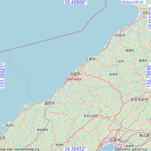
Hamada GPS coordinates[2]
34° 52' 59.988" North, 132° 4' 59.988" East
| Map corner | latitude | longitude |
|---|---|---|
| Upper-left | 35.45809°, | 131.38021° |
| Center: | 34.88333°, | 132.08333° |
| Lower-right: | 34.30452°, | 132.78646° |
| Map W x H: | 128.3×128.3 km | = 79.7×79.7mi |
| max Lat: | 45.40944° ⇑61.7% North |
| Hamada: | 34.88333° |
| min Lat: | ⇓38.3% South 24.34478° |
| min Long | Hamada | max Long |
| 123° | 132.08333° | 145.575° |
| W 17.4%⇐ | ⇒82.6% E |
Elevation
Elevation of Hamada is 142 m = 466 ft, and this is 57.4 m = 188 ft above average elevation for this country.
| Max E: |
1086 m = 3563 ft | 17.7% |
| Hamada | 142 m 466 ft | |
| Avg. | 84.6 m = 278 ft | |
Min E: |
-2 m = -7 ft | 82.3% |
See also: Hamada elevation on elevation.city.
Geographical zone
Hamada is located in North temperate zone (between Tropic of Cancer and the Arctic Circle). Distance of this Northern Tropic circle is 1272.7 km =790.8 mi to South.| Distance of | km | miles | from Hamada |
|---|---|---|---|
| North Pole | 6128.4 | 3808 | to North |
| Arctic Circle | 3522.5 | 2188.8 | to North |
| Tropic Cancer | 1272.7 | 790.8 | to South |
| Equator | 3878.7 | 2410.1 | to South |


Nearby cities:
15 places around Hamada: (largest is in red/bold)
• Aki-takata
59.4 km =36.9 mi,  113°
113°
• Etajima
80.3 km =49.9 mi,  153°
153°
• Gōtsuchō
19 km =11.8 mi,  42°
42°
• Hagi
81.3 km =50.5 mi,  228°
228°
• Hatsukaichi
63.6 km =39.5 mi,  158°
158°
• Higashihiroshima
79.7 km =49.5 mi,  131°
131°
• Hiroshima
63.3 km =39.3 mi, 148°
• Iwakuni
81.1 km =50.4 mi,  171°
171°
• Masuda
32.2 km =20 mi,  221°
221°
• Miyajima
68.5 km =42.6 mi, 161°
• Miyoshi
70.6 km =43.9 mi,  97°
97°
• Oda
51.8 km =32.2 mi,  47°
47°
• Ōdachō-ōda
51.6 km =32.1 mi, 48°
• Ōno-hara
68.8 km =42.8 mi, 165°
• Ōtake
76.2 km =47.3 mi, 170°
Sources, notices
• [Note1] Compared only with cities in Japan existing in our database
• [Src1] Map data: © OpenStreetMap contributors (CC-BY-SA)
• [Src2] Other city data from geonames.org with taken over terms of usage.
• [Src3] Geographical zone / Annual Mean Temperature by Robert A. Rohde @ Wikipedia
