Hatsukaichi geodata
Hatsukaichi (Hiroshima) is a seat of a second-order administrative division; located in Japan in Asia/Tokyo (GMT+9) time zone. With population of 77,341 people, there are 260 cities with bigger population in this country. Compared to other cities in Japan, 74.9% of cities are located further ↑North; 81.9% of cities are located further →East and 93.5% of cities have higher elevation than Hatsukaichi. Note1


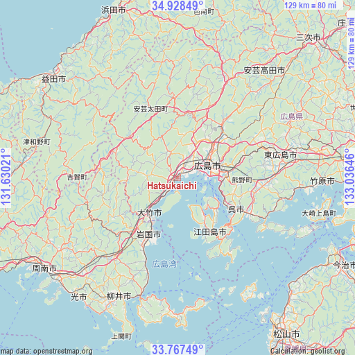
Hatsukaichi GPS coordinates[2]
34° 21' 0" North, 132° 19' 59.988" East
| Map corner | latitude | longitude |
|---|---|---|
| Upper-left | 34.92849°, | 131.63021° |
| Center: | 34.35°, | 132.33333° |
| Lower-right: | 33.76749°, | 133.03646° |
| Map W x H: | 129.1×129.1 km | = 80.2×80.2mi |
| max Lat: | 45.40944° ⇑74.9% North |
| Hatsukaichi: | 34.35° |
| min Lat: | ⇓25.1% South 24.34478° |
| min Long | Hatsukaichi | max Long |
| 123° | 132.33333° | 145.575° |
| W 18.1%⇐ | ⇒81.9% E |
Elevation
Elevation of Hatsukaichi is 4 m = 13 ft, and this is 80.6 m = 264 ft below average elevation for this country.
| Max E: |
1086 m = 3563 ft | 93.5% |
| Avg. | 84.6 m = 278 ft | |
| Hatsukaichi | 4 m = 13 ft | |
Min E: |
-2 m = -7 ft | 6.5% |
See also: Hatsukaichi elevation on elevation.city.
Geographical zone
Hatsukaichi is located in North temperate zone (between Tropic of Cancer and the Arctic Circle). Distance of this Northern Tropic circle is 1213.4 km =754 mi to South.| Distance of | km | miles | from Hatsukaichi |
|---|---|---|---|
| North Pole | 6187.7 | 3844.9 | to North |
| Arctic Circle | 3581.8 | 2225.6 | to North |
| Tropic Cancer | 1213.4 | 754 | to South |
| Equator | 3819.4 | 2373.3 | to South |


Nearby cities:
15 places around Hatsukaichi: (largest is in red/bold)
• Aki-takata
48.2 km =30 mi,  41°
41°
• Etajima
18.3 km =11.4 mi,  132°
132°
• Higashihiroshima
37.6 km =23.4 mi,  80°
80°
• Hikari
56.3 km =35 mi,  218°
218°
• Hiroshima
12.1 km =7.5 mi,  62°
62°
• Iwakuni
23.3 km =14.5 mi,  206°
206°
• Kudamatsu
57.9 km =36 mi,  227°
227°
• Kure
25.1 km =15.6 mi,  121°
121°
• Masuda
56.6 km =35.2 mi,  308°
308°
• Miyajima
5.8 km =3.6 mi,  190°
190°
• Shūnan
55.5 km =34.5 mi,  237°
237°
• Takehara
53.6 km =33.3 mi,  91°
91°
• Yanai
47.1 km =29.3 mi, 205°
• Ōno-hara
9.6 km =6 mi, 219°
• Ōtake
18.9 km =11.7 mi, 213°
Sources, notices
• [Note1] Compared only with cities in Japan existing in our database
• [Src1] Map data: © OpenStreetMap contributors (CC-BY-SA)
• [Src2] Other city data from geonames.org with taken over terms of usage.
• [Src3] Geographical zone / Annual Mean Temperature by Robert A. Rohde @ Wikipedia
