Iwakuni geodata
Iwakuni (Yamaguchi) is a seat of a second-order administrative division; located in Japan in Asia/Tokyo (GMT+9) time zone. With population of 104,004 people, there are 194 cities with bigger population in this country. Compared to other cities in Japan, 78.2% of cities are located further ↑North; 82.4% of cities are located further →East and 93.5% of cities have higher elevation than Iwakuni. Note1


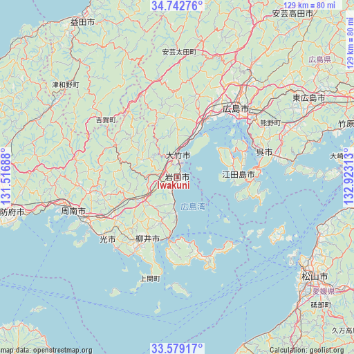
Iwakuni GPS coordinates[2]
34° 9' 46.692" North, 132° 13' 12" East
| Map corner | latitude | longitude |
|---|---|---|
| Upper-left | 34.74276°, | 131.51688° |
| Center: | 34.16297°, | 132.22° |
| Lower-right: | 33.57917°, | 132.92313° |
| Map W x H: | 129.4×129.4 km | = 80.4×80.4mi |
| max Lat: | 45.40944° ⇑78.2% North |
| Iwakuni: | 34.16297° |
| min Lat: | ⇓21.8% South 24.34478° |
| min Long | Iwakuni | max Long |
| 123° | 132.22° | 145.575° |
| W 17.6%⇐ | ⇒82.4% E |
Elevation
Elevation of Iwakuni is 4 m = 13 ft, and this is 80.6 m = 264 ft below average elevation for this country.
| Max E: |
1086 m = 3563 ft | 93.5% |
| Avg. | 84.6 m = 278 ft | |
| Iwakuni | 4 m = 13 ft | |
Min E: |
-2 m = -7 ft | 6.5% |
See also: Iwakuni elevation on elevation.city.
Geographical zone
Iwakuni is located in North temperate zone (between Tropic of Cancer and the Arctic Circle). Distance of this Northern Tropic circle is 1192.6 km =741 mi to South.| Distance of | km | miles | from Iwakuni |
|---|---|---|---|
| North Pole | 6208.5 | 3857.8 | to North |
| Arctic Circle | 3602.6 | 2238.6 | to North |
| Tropic Cancer | 1192.6 | 741 | to South |
| Equator | 3798.6 | 2360.3 | to South |


Nearby cities:
15 places around Iwakuni: (largest is in red/bold)
• Etajima
25.3 km =15.7 mi,  70°
70°
• Hatsukaichi
23.3 km =14.5 mi,  26°
26°
• Higashihiroshima
54.8 km =34.1 mi,  60°
60°
• Hikari
34 km =21.1 mi,  227°
227°
• Hiroshima
33.8 km =21 mi,  38°
38°
• Hōfu
61.4 km =38.2 mi,  258°
258°
• Hōjō
55.4 km =34.4 mi,  111°
111°
• Kudamatsu
37.2 km =23.1 mi,  240°
240°
• Kure
32.8 km =20.4 mi,  76°
76°
• Miyajima
17.8 km =11.1 mi, 31°
• Shūnan
37.4 km =23.2 mi, 255°
• Tokuyama
39.2 km =24.4 mi,  251°
251°
• Yanai
23.8 km =14.8 mi,  203°
203°
• Ōno-hara
14.1 km =8.8 mi,  17°
17°
• Ōtake
5 km =3.1 mi,  0°
0°
Sources, notices
• [Note1] Compared only with cities in Japan existing in our database
• [Src1] Map data: © OpenStreetMap contributors (CC-BY-SA)
• [Src2] Other city data from geonames.org with taken over terms of usage.
• [Src3] Geographical zone / Annual Mean Temperature by Robert A. Rohde @ Wikipedia
