Aki geodata
Aki (Kochi) is a seat of a second-order administrative division; located in Japan in Asia/Tokyo (GMT+9) time zone. With population of 20,117 people, there are 694 cities with bigger population in this country. Compared to other cities in Japan, 85.7% of cities are located further ↑North; 75.3% of cities are located further →East and 68.3% of cities have higher elevation than Aki. Note1


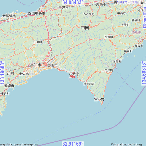
Aki GPS coordinates[2]
33° 30' 0" North, 133° 54' 0" East
| Map corner | latitude | longitude |
|---|---|---|
| Upper-left | 34.08433°, | 133.19688° |
| Center: | 33.5°, | 133.9° |
| Lower-right: | 32.91169°, | 134.60313° |
| Map W x H: | 130.4×130.4 km | = 81×81mi |
| max Lat: | 45.40944° ⇑85.7% North |
| Aki: | 33.5° |
| min Lat: | ⇓14.3% South 24.34478° |
| min Long | Aki | max Long |
| 123° | 133.9° | 145.575° |
| W 24.7%⇐ | ⇒75.3% E |
Elevation
Elevation of Aki is 13 m = 43 ft, and this is 71.6 m = 235 ft below average elevation for this country.
| Max E: |
1086 m = 3563 ft | 68.3% |
| Avg. | 84.6 m = 278 ft | |
| Aki | 13 m = 43 ft | |
Min E: |
-2 m = -7 ft | 31.7% |
See also: Japan elevation on elevation.city.
Geographical zone
Aki is located in North temperate zone (between Tropic of Cancer and the Arctic Circle). Distance of this Northern Tropic circle is 1118.9 km =695.3 mi to South.| Distance of | km | miles | from Aki |
|---|---|---|---|
| North Pole | 6282.2 | 3903.6 | to North |
| Arctic Circle | 3676.3 | 2284.3 | to North |
| Tropic Cancer | 1118.9 | 695.3 | to South |
| Equator | 3724.9 | 2314.5 | to South |


Nearby cities:
15 places around Aki: (largest is in red/bold)
• Ikedachō
59.4 km =36.9 mi,  351°
351°
• Ino
43.6 km =27.1 mi,  277°
277°
• Kami
21.1 km =13.1 mi, 345°
• Kawanoechō
64.7 km =40.2 mi,  332°
332°
• Kochi
34.4 km =21.4 mi, 279°
• Kōnan
14.3 km =8.9 mi,  310°
310°
• Mima
65.6 km =40.8 mi,  19°
19°
• Miyoshi
47.5 km =29.5 mi,  355°
355°
• Muroto
29.1 km =18.1 mi,  129°
129°
• Muroto-misakicho
34.4 km =21.4 mi, 133°
• Nankoku
24.5 km =15.2 mi,  288°
288°
• Shikokuchūō
62 km =38.5 mi, 328°
• Susaki
57.7 km =35.9 mi,  258°
258°
• Tosa
42.2 km =26.2 mi,  270°
270°
• Wakimachi
67.1 km =41.7 mi, 20°
Sources, notices
• [Note1] Compared only with cities in Japan existing in our database
• [Src1] Map data: © OpenStreetMap contributors (CC-BY-SA)
• [Src2] Other city data from geonames.org with taken over terms of usage.
• [Src3] Geographical zone / Annual Mean Temperature by Robert A. Rohde @ Wikipedia
