Mima geodata
Mima (Tokushima) is a seat of a second-order administrative division; located in Japan in Asia/Tokyo (GMT+9) time zone. In our database, there are 767 cities with bigger population. Compared to other cities in Japan, 79.5% of cities are located further ↑North; 74.8% of cities are located further →East and 59.6% of cities have lower elevation than Mima. Note1


Mima GPS coordinates[2]
34° 3' 17.748" North, 134° 8' 22.668" East
| Map corner | latitude | longitude |
|---|---|---|
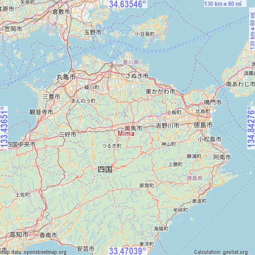
| Upper-left | 34.63546°, | 133.43651° |
| Center: | 34.05493°, | 134.13963° |
| Lower-right: | 33.47039°, | 134.84276° |
| Map W x H: | 129.5×129.5 km | = 80.5×80.5mi |
| max Lat: | 45.40944° ⇑79.5% North |
| Mima: | 34.05493° |
| min Lat: | ⇓20.5% South 24.34478° |
| min Long | Mima | max Long |
| 123° | 134.13963° | 145.575° |
| W 25.2%⇐ | ⇒74.8% E |
Elevation
Elevation of Mima is 45 m = 148 ft, and this is 39.6 m = 130 ft below average elevation for this country.
| Max E: |
1086 m = 3563 ft | 40.4% |
| Avg. | 84.6 m = 278 ft | |
| Mima | 45 m = 148 ft | |
Min E: |
-2 m = -7 ft | 59.6% |
See also: Japan elevation on elevation.city.
Geographical zone
Mima is located in North temperate zone (between Tropic of Cancer and the Arctic Circle). Distance of this Northern Tropic circle is 1180.6 km =733.6 mi to South.| Distance of | km | miles | from Mima |
|---|---|---|---|
| North Pole | 6220.5 | 3865.2 | to North |
| Arctic Circle | 3614.6 | 2246 | to North |
| Tropic Cancer | 1180.6 | 733.6 | to South |
| Equator | 3786.6 | 2352.9 | to South |


Nearby cities:
15 places around Mima: (largest is in red/bold)
• Awa
14 km =8.7 mi,  72°
72°
• Higashikagawa
25 km =15.5 mi,  46°
46°
• Ikedachō
30.9 km =19.2 mi,  264°
264°
• Ishii
27.9 km =17.3 mi,  87°
87°
• Kamojimachō-jōgejima
19.5 km =12.1 mi, 85°
• Komatsushimachō
41.3 km =25.7 mi,  98°
98°
• Miyoshi
29.8 km =18.5 mi,  241°
241°
• Sakaidechō
40.9 km =25.4 mi,  316°
316°
• Sanuki
25 km =15.5 mi,  19°
19°
• Shido
30 km =18.6 mi,  5°
5°
• Takamatsu
32 km =19.9 mi,  345°
345°
• Tokushima
39.4 km =24.5 mi, 88°
• Wakimachi
1.6 km =1 mi,  36°
36°
• Yoshinogawa
14.2 km =8.8 mi, 97°
• Zentsujichó
38.4 km =23.9 mi,  299°
299°
Sources, notices
• [Note1] Compared only with cities in Japan existing in our database
• [Src1] Map data: © OpenStreetMap contributors (CC-BY-SA)
• [Src2] Other city data from geonames.org with taken over terms of usage.
• [Src3] Geographical zone / Annual Mean Temperature by Robert A. Rohde @ Wikipedia
