Kochi geodata
Kochi is a seat of a first-order administrative division; located in Japan in Asia/Tokyo (GMT+9) time zone. With population of 335,570 people, there are 57 cities with bigger population in this country. Compared to other cities in Japan, 85% of cities are located further ↑North; 77.3% of cities are located further →East and 65.4% of cities have lower elevation than Kochi. Note1


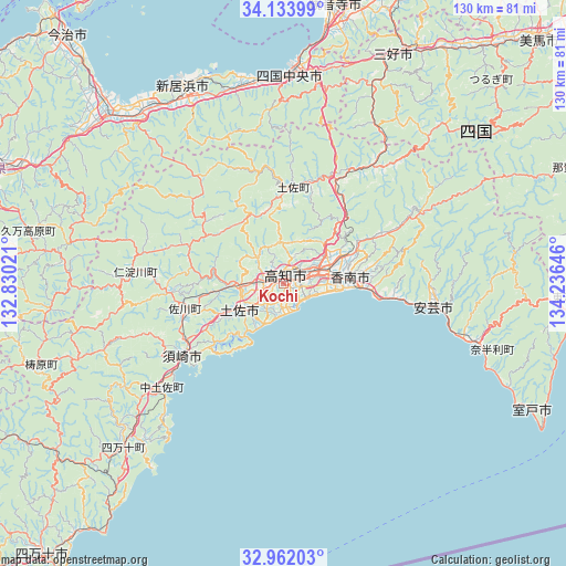
Kochi GPS coordinates[2]
33° 33' 0" North, 133° 31' 59.988" East
| Map corner | latitude | longitude |
|---|---|---|
| Upper-left | 34.13399°, | 132.83021° |
| Center: | 33.55°, | 133.53333° |
| Lower-right: | 32.96203°, | 134.23646° |
| Map W x H: | 130.3×130.3 km | = 81×81mi |
| max Lat: | 45.40944° ⇑85% North |
| Kochi: | 33.55° |
| min Lat: | ⇓15% South 24.34478° |
| min Long | Kochi | max Long |
| 123° | 133.53333° | 145.575° |
| W 22.7%⇐ | ⇒77.3% E |
Elevation
Elevation of Kochi is 58 m = 190 ft, and this is 26.6 m = 87 ft below average elevation for this country.
| Max E: |
1086 m = 3563 ft | 34.6% |
| Avg. | 84.6 m = 278 ft | |
| Kochi | 58 m = 190 ft | |
Min E: |
-2 m = -7 ft | 65.4% |
See also: Kochi elevation on elevation.city.
Geographical zone
Kochi is located in North temperate zone (between Tropic of Cancer and the Arctic Circle). Distance of this Northern Tropic circle is 1124.5 km =698.7 mi to South.| Distance of | km | miles | from Kochi |
|---|---|---|---|
| North Pole | 6276.7 | 3900.2 | to North |
| Arctic Circle | 3670.8 | 2280.9 | to North |
| Tropic Cancer | 1124.5 | 698.7 | to South |
| Equator | 3730.4 | 2318 | to South |


Nearby cities:
15 places around Kochi: (largest is in red/bold)
• Aki
34.4 km =21.4 mi,  99°
99°
• Ikedachō
58.9 km =36.6 mi,  25°
25°
• Ino
9.3 km =5.8 mi,  270°
270°
• Kami
32.4 km =20.1 mi,  62°
62°
• Kan’onji
58.8 km =36.5 mi,  10°
10°
• Kawanoechō
52 km =32.3 mi,  4°
4°
• Kōnan
23.3 km =14.5 mi,  80°
80°
• Miyoshi
51.3 km =31.9 mi,  35°
35°
• Muroto
61.4 km =38.2 mi,  113°
113°
• Nankoku
11 km =6.8 mi, 78°
• Niihama
50.3 km =31.3 mi,  335°
335°
• Saijō
52.1 km =32.4 mi,  321°
321°
• Shikokuchūō
47.3 km =29.4 mi, 1°
• Susaki
28.3 km =17.6 mi,  232°
232°
• Tosa
9.6 km =6 mi,  238°
238°
Sources, notices
• [Note1] Compared only with cities in Japan existing in our database
• [Src1] Map data: © OpenStreetMap contributors (CC-BY-SA)
• [Src2] Other city data from geonames.org with taken over terms of usage.
• [Src3] Geographical zone / Annual Mean Temperature by Robert A. Rohde @ Wikipedia
