Nankoku geodata
Nankoku (Kochi) is a seat of a second-order administrative division; located in Japan in Asia/Tokyo (GMT+9) time zone. In our database, there are 767 cities with bigger population. Compared to other cities in Japan, 84.4% of cities are located further ↑North; 76.6% of cities are located further →East and 66.8% of cities have higher elevation than Nankoku. Note1


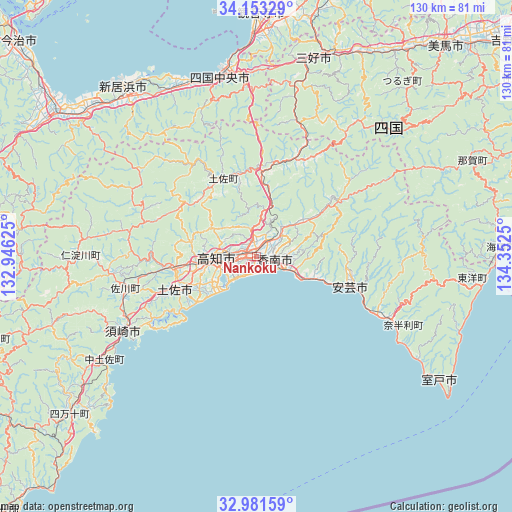
Nankoku GPS coordinates[2]
33° 34' 9.948" North, 133° 38' 57.732" East
| Map corner | latitude | longitude |
|---|---|---|
| Upper-left | 34.15329°, | 132.94625° |
| Center: | 33.56943°, | 133.64937° |
| Lower-right: | 32.98159°, | 134.3525° |
| Map W x H: | 130.3×130.3 km | = 81×81mi |
| max Lat: | 45.40944° ⇑84.4% North |
| Nankoku: | 33.56943° |
| min Lat: | ⇓15.6% South 24.34478° |
| min Long | Nankoku | max Long |
| 123° | 133.64937° | 145.575° |
| W 23.4%⇐ | ⇒76.6% E |
Elevation
Elevation of Nankoku is 14 m = 46 ft, and this is 70.6 m = 232 ft below average elevation for this country.
| Max E: |
1086 m = 3563 ft | 66.8% |
| Avg. | 84.6 m = 278 ft | |
| Nankoku | 14 m = 46 ft | |
Min E: |
-2 m = -7 ft | 33.2% |
See also: Japan elevation on elevation.city.
Geographical zone
Nankoku is located in North temperate zone (between Tropic of Cancer and the Arctic Circle). Distance of this Northern Tropic circle is 1126.7 km =700.1 mi to South.| Distance of | km | miles | from Nankoku |
|---|---|---|---|
| North Pole | 6274.5 | 3898.8 | to North |
| Arctic Circle | 3668.6 | 2279.6 | to North |
| Tropic Cancer | 1126.7 | 700.1 | to South |
| Equator | 3732.6 | 2319.3 | to South |


Nearby cities:
15 places around Nankoku: (largest is in red/bold)
• Aki
24.5 km =15.2 mi,  108°
108°
• Ikedachō
53.1 km =33 mi,  15°
15°
• Ino
20.1 km =12.5 mi,  263°
263°
• Kami
22 km =13.7 mi,  54°
54°
• Kan’onji
55.6 km =34.5 mi,  359°
359°
• Kawanoechō
50.1 km =31.1 mi,  352°
352°
• Kochi
11 km =6.8 mi, 258°
• Kōnan
12.4 km =7.7 mi,  82°
82°
• Miyoshi
44 km =27.3 mi,  25°
25°
• Muroto
52.7 km =32.7 mi,  119°
119°
• Muroto-misakicho
57.5 km =35.7 mi, 123°
• Niihama
53.9 km =33.5 mi,  323°
323°
• Shikokuchūō
46.1 km =28.6 mi, 348°
• Susaki
38.5 km =23.9 mi,  239°
239°
• Tosa
20.3 km =12.6 mi,  249°
249°
Sources, notices
• [Note1] Compared only with cities in Japan existing in our database
• [Src1] Map data: © OpenStreetMap contributors (CC-BY-SA)
• [Src2] Other city data from geonames.org with taken over terms of usage.
• [Src3] Geographical zone / Annual Mean Temperature by Robert A. Rohde @ Wikipedia
