Susaki geodata
Susaki (Kochi) is a seat of a second-order administrative division; located in Japan in Asia/Tokyo (GMT+9) time zone. With population of 26,195 people, there are 590 cities with bigger population in this country. Compared to other cities in Japan, 86.6% of cities are located further ↑North; 78.3% of cities are located further →East and 86% of cities have higher elevation than Susaki. Note1


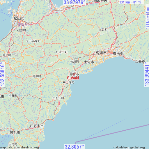
Susaki GPS coordinates[2]
33° 23' 40.956" North, 133° 17' 28.608" East
| Map corner | latitude | longitude |
|---|---|---|
| Upper-left | 33.97976°, | 132.58816° |
| Center: | 33.39471°, | 133.29128° |
| Lower-right: | 32.8057°, | 133.99441° |
| Map W x H: | 130.5×130.5 km | = 81.1×81.1mi |
| max Lat: | 45.40944° ⇑86.6% North |
| Susaki: | 33.39471° |
| min Lat: | ⇓13.4% South 24.34478° |
| min Long | Susaki | max Long |
| 123° | 133.29128° | 145.575° |
| W 21.7%⇐ | ⇒78.3% E |
Elevation
Elevation of Susaki is 6 m = 20 ft, and this is 78.6 m = 258 ft below average elevation for this country.
| Max E: |
1086 m = 3563 ft | 86% |
| Avg. | 84.6 m = 278 ft | |
| Susaki | 6 m = 20 ft | |
Min E: |
-2 m = -7 ft | 14% |
See also: Japan elevation on elevation.city.
Geographical zone
Susaki is located in North temperate zone (between Tropic of Cancer and the Arctic Circle). Distance of this Northern Tropic circle is 1107.2 km =688 mi to South.| Distance of | km | miles | from Susaki |
|---|---|---|---|
| North Pole | 6293.9 | 3910.8 | to North |
| Arctic Circle | 3688 | 2291.6 | to North |
| Tropic Cancer | 1107.2 | 688 | to South |
| Equator | 3713.1 | 2307.2 | to South |


Nearby cities:
15 places around Susaki: (largest is in red/bold)
• Aki
57.7 km =35.9 mi,  78°
78°
• Ino
21.7 km =13.5 mi,  37°
37°
• Iyo
67.5 km =41.9 mi,  305°
305°
• Kami
60.5 km =37.6 mi,  57°
57°
• Kihoku-chō
58.5 km =36.4 mi,  254°
254°
• Kochi
28.3 km =17.6 mi,  52°
52°
• Kōnan
50.1 km =31.1 mi,  65°
65°
• Nakamura
56.6 km =35.2 mi,  216°
216°
• Nankoku
38.5 km =23.9 mi, 59°
• Niihama
62.9 km =39.1 mi,  1°
1°
• Saijō
58.9 km =36.6 mi,  350°
350°
• Seiyo
61.2 km =38 mi,  269°
269°
• Shimanto
53.9 km =33.5 mi,  229°
229°
• Tosa
18.8 km =11.7 mi, 49°
• Tōon
57.9 km =36 mi,  320°
320°
Sources, notices
• [Note1] Compared only with cities in Japan existing in our database
• [Src1] Map data: © OpenStreetMap contributors (CC-BY-SA)
• [Src2] Other city data from geonames.org with taken over terms of usage.
• [Src3] Geographical zone / Annual Mean Temperature by Robert A. Rohde @ Wikipedia
