Wakuya geodata
Wakuya (Miyagi) is a populated place; located in Japan in Asia/Tokyo (GMT+9) time zone. With population of 18,334 people, there are 720 cities with bigger population in this country. Compared to other cities in Japan, 89.5% of cities are located further ↓South; 93.8% of cities are located further ←West and 50.9% of cities have lower elevation than Wakuya. Note1


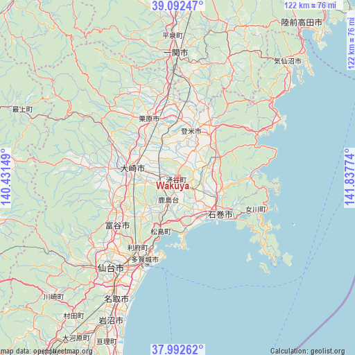
Wakuya GPS coordinates[2]
38° 32' 40.74" North, 141° 8' 4.596" East
| Map corner | latitude | longitude |
|---|---|---|
| Upper-left | 39.09247°, | 140.43149° |
| Center: | 38.54465°, | 141.13461° |
| Lower-right: | 37.99262°, | 141.83774° |
| Map W x H: | 122.3×122.3 km | = 76×76mi |
| max Lat: | 45.40944° ⇑10.5% North |
| Wakuya: | 38.54465° |
| min Lat: | ⇓89.5% South 24.34478° |
| min Long | Wakuya | max Long |
| 123° | 141.13461° | 145.575° |
| W 93.8%⇐ | ⇒6.2% E |
Elevation
Elevation of Wakuya is 29 m = 95 ft, and this is 55.6 m = 182 ft below average elevation for this country.
| Max E: |
1086 m = 3563 ft | 49.1% |
| Avg. | 84.6 m = 278 ft | |
| Wakuya | 29 m = 95 ft | |
Min E: |
-2 m = -7 ft | 50.9% |
See also: Japan elevation on elevation.city.
Geographical zone
Wakuya is located in North temperate zone (between Tropic of Cancer and the Arctic Circle). Distance of this Northern Tropic circle is 1679.8 km =1043.8 mi to South.| Distance of | km | miles | from Wakuya |
|---|---|---|---|
| North Pole | 5721.3 | 3555 | to North |
| Arctic Circle | 3115.4 | 1935.8 | to North |
| Tropic Cancer | 1679.8 | 1043.8 | to South |
| Equator | 4285.8 | 2663.1 | to South |


Nearby cities:
15 places around Wakuya: (largest is in red/bold)
• Furukawa
15.9 km =9.9 mi,  280°
280°
• Higashimatsushima
15.6 km =9.7 mi,  165°
165°
• Ishinomaki
20.2 km =12.6 mi,  134°
134°
• Kogota
7.4 km =4.6 mi,  274°
274°
• Kurihara
25.7 km =16 mi,  332°
332°
• Matsushima
20.1 km =12.5 mi,  198°
198°
• Onagawa Chō
29.4 km =18.3 mi,  111°
111°
• Rifu
27.4 km =17 mi,  210°
210°
• Sendai
38.7 km =24 mi,  217°
217°
• Shiogama
26.8 km =16.7 mi, 199°
• Tagajō-shi
29.6 km =18.4 mi, 203°
• Tome
18.3 km =11.4 mi,  5°
5°
• Tomiya
27.4 km =17 mi,  232°
232°
• Yamoto
14.8 km =9.2 mi,  151°
151°
• Ōsaki
14.9 km =9.3 mi,  289°
289°
Sources, notices
• [Note1] Compared only with cities in Japan existing in our database
• [Src1] Map data: © OpenStreetMap contributors (CC-BY-SA)
• [Src2] Other city data from geonames.org with taken over terms of usage.
• [Src3] Geographical zone / Annual Mean Temperature by Robert A. Rohde @ Wikipedia
