Onagawa Chō geodata
Onagawa Chō (Miyagi) is a seat of a second-order administrative division; located in Japan in Asia/Tokyo (GMT+9) time zone. In our database, there are 767 cities with bigger population. Compared to other cities in Japan, 89.4% of cities are located further ↓South; 95.6% of cities are located further ←West and 52.3% of cities have higher elevation than Onagawa Chō. Note1


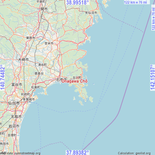
Onagawa Chō GPS coordinates[2]
38° 26' 47.76" North, 141° 26' 52.584" East
| Map corner | latitude | longitude |
|---|---|---|
| Upper-left | 38.99518°, | 140.74482° |
| Center: | 38.4466°, | 141.44794° |
| Lower-right: | 37.89382°, | 142.15107° |
| Map W x H: | 122.5×122.5 km | = 76.1×76.1mi |
| max Lat: | 45.40944° ⇑10.6% North |
| Onagawa Chō: | 38.4466° |
| min Lat: | ⇓89.4% South 24.34478° |
| min Long | Onagawa Chō | max Long |
| 123° | 141.44794° | 145.575° |
| W 95.6%⇐ | ⇒4.4% E |
Elevation
Elevation of Onagawa Chō is 26 m = 85 ft, and this is 58.6 m = 192 ft below average elevation for this country.
| Max E: |
1086 m = 3563 ft | 52.3% |
| Avg. | 84.6 m = 278 ft | |
| Onagawa Chō | 26 m = 85 ft | |
Min E: |
-2 m = -7 ft | 47.7% |
See also: Japan elevation on elevation.city.
Geographical zone
Onagawa Chō is located in North temperate zone (between Tropic of Cancer and the Arctic Circle). Distance of this Northern Tropic circle is 1668.9 km =1037 mi to South.| Distance of | km | miles | from Onagawa Chō |
|---|---|---|---|
| North Pole | 5732.2 | 3561.8 | to North |
| Arctic Circle | 3126.3 | 1942.6 | to North |
| Tropic Cancer | 1668.9 | 1037 | to South |
| Equator | 4274.9 | 2656.3 | to South |


Nearby cities:
15 places around Onagawa Chō: (largest is in red/bold)
• Furukawa
45 km =28 mi,  287°
287°
• Higashimatsushima
23.8 km =14.8 mi,  259°
259°
• Ishinomaki
13.3 km =8.3 mi, 255°
• Kesennuma
51.8 km =32.2 mi,  12°
12°
• Kogota
36.5 km =22.7 mi, 288°
• Kurihara
51.5 km =32 mi,  310°
310°
• Matsushima
34.7 km =21.6 mi, 256°
• Rifu
43 km =26.7 mi,  252°
252°
• Shiogama
38.9 km =24.2 mi, 248°
• Tagajō-shi
42.3 km =26.3 mi, 247°
• Tome
38.7 km =24 mi,  318°
318°
• Tomiya
49.3 km =30.6 mi, 263°
• Wakuya
29.4 km =18.3 mi, 291°
• Yamoto
20.4 km =12.7 mi, 263°
• Ōsaki
44.2 km =27.5 mi, 290°
Sources, notices
• [Note1] Compared only with cities in Japan existing in our database
• [Src1] Map data: © OpenStreetMap contributors (CC-BY-SA)
• [Src2] Other city data from geonames.org with taken over terms of usage.
• [Src3] Geographical zone / Annual Mean Temperature by Robert A. Rohde @ Wikipedia
