Matsushima geodata
Matsushima (Miyagi) is a seat of a third-order administrative division; located in Japan in Asia/Tokyo (GMT+9) time zone. With population of 16,363 people, there are 732 cities with bigger population in this country. Compared to other cities in Japan, 88.8% of cities are located further ↓South; 93.2% of cities are located further ←West and 59.1% of cities have higher elevation than Matsushima. Note1


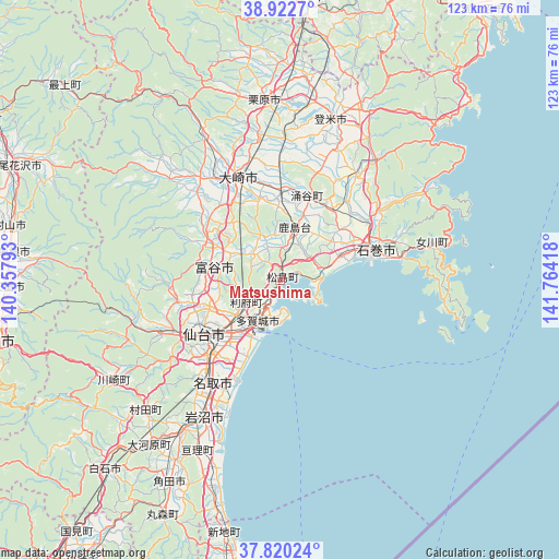
Matsushima GPS coordinates[2]
38° 22' 24.852" North, 141° 3' 39.78" East
| Map corner | latitude | longitude |
|---|---|---|
| Upper-left | 38.9227°, | 140.35793° |
| Center: | 38.37357°, | 141.06105° |
| Lower-right: | 37.82024°, | 141.76418° |
| Map W x H: | 122.6×122.6 km | = 76.2×76.2mi |
| max Lat: | 45.40944° ⇑11.2% North |
| Matsushima: | 38.37357° |
| min Lat: | ⇓88.8% South 24.34478° |
| min Long | Matsushima | max Long |
| 123° | 141.06105° | 145.575° |
| W 93.2%⇐ | ⇒6.8% E |
Elevation
Elevation of Matsushima is 20 m = 66 ft, and this is 64.6 m = 212 ft below average elevation for this country.
| Max E: |
1086 m = 3563 ft | 59.1% |
| Avg. | 84.6 m = 278 ft | |
| Matsushima | 20 m = 66 ft | |
Min E: |
-2 m = -7 ft | 40.9% |
See also: Japan elevation on elevation.city.
Geographical zone
Matsushima is located in North temperate zone (between Tropic of Cancer and the Arctic Circle). Distance of this Northern Tropic circle is 1660.8 km =1032 mi to South.| Distance of | km | miles | from Matsushima |
|---|---|---|---|
| North Pole | 5740.3 | 3566.9 | to North |
| Arctic Circle | 3134.4 | 1947.6 | to North |
| Tropic Cancer | 1660.8 | 1032 | to South |
| Equator | 4266.7 | 2651.2 | to South |


Nearby cities:
15 places around Matsushima: (largest is in red/bold)
• Furukawa
23.9 km =14.9 mi,  337°
337°
• Higashimatsushima
11 km =6.8 mi,  69°
69°
• Ishinomaki
21.4 km =13.3 mi,  77°
77°
• Iwanuma
34.7 km =21.6 mi,  210°
210°
• Kogota
19.6 km =12.2 mi,  357°
357°
• Natori-shi
27.7 km =17.2 mi, 213°
• Onagawa Chō
34.7 km =21.6 mi, 76°
• Rifu
8.7 km =5.4 mi,  237°
237°
• Sendai
20.7 km =12.9 mi,  234°
234°
• Shiogama
6.8 km =4.2 mi,  200°
200°
• Tagajō-shi
9.8 km =6.1 mi, 213°
• Tomiya
15.4 km =9.6 mi,  278°
278°
• Wakuya
20.1 km =12.5 mi,  18°
18°
• Yamoto
14.7 km =9.1 mi, 65°
• Ōsaki
25.1 km =15.6 mi, 342°
Sources, notices
• [Note1] Compared only with cities in Japan existing in our database
• [Src1] Map data: © OpenStreetMap contributors (CC-BY-SA)
• [Src2] Other city data from geonames.org with taken over terms of usage.
• [Src3] Geographical zone / Annual Mean Temperature by Robert A. Rohde @ Wikipedia
