Tomiya geodata
Tomiya (Miyagi) is a populated place; located in Japan in Asia/Tokyo (GMT+9) time zone. With population of 42,500 people, there are 428 cities with bigger population in this country. Compared to other cities in Japan, 88.9% of cities are located further ↓South; 91.9% of cities are located further ←West and 67.4% of cities have lower elevation than Tomiya. Note1


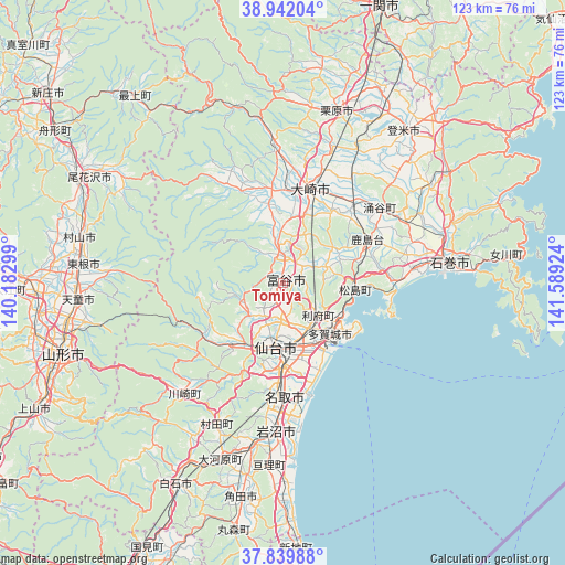
Tomiya GPS coordinates[2]
38° 23' 35.016" North, 140° 53' 9.996" East
| Map corner | latitude | longitude |
|---|---|---|
| Upper-left | 38.94204°, | 140.18299° |
| Center: | 38.39306°, | 140.88611° |
| Lower-right: | 37.83988°, | 141.58924° |
| Map W x H: | 122.5×122.5 km | = 76.1×76.1mi |
| max Lat: | 45.40944° ⇑11.1% North |
| Tomiya: | 38.39306° |
| min Lat: | ⇓88.9% South 24.34478° |
| min Long | Tomiya | max Long |
| 123° | 140.88611° | 145.575° |
| W 91.9%⇐ | ⇒8.1% E |
Elevation
Elevation of Tomiya is 64 m = 210 ft, and this is 20.6 m = 68 ft below average elevation for this country.
| Max E: |
1086 m = 3563 ft | 32.6% |
| Avg. | 84.6 m = 278 ft | |
| Tomiya | 64 m = 210 ft | |
Min E: |
-2 m = -7 ft | 67.4% |
See also: Tomiya elevation on elevation.city.
Geographical zone
Tomiya is located in North temperate zone (between Tropic of Cancer and the Arctic Circle). Distance of this Northern Tropic circle is 1663 km =1033.3 mi to South.| Distance of | km | miles | from Tomiya |
|---|---|---|---|
| North Pole | 5738.2 | 3565.6 | to North |
| Arctic Circle | 3132.3 | 1946.3 | to North |
| Tropic Cancer | 1663 | 1033.3 | to South |
| Equator | 4268.9 | 2652.6 | to South |


Nearby cities:
15 places around Tomiya: (largest is in red/bold)
• Furukawa
20.8 km =12.9 mi,  16°
16°
• Higashimatsushima
25.6 km =15.9 mi,  86°
86°
• Ishinomaki
36.2 km =22.5 mi, 85°
• Iwanuma
32.1 km =19.9 mi,  184°
184°
• Kogota
22.5 km =14 mi,  39°
39°
• Matsushima
15.4 km =9.6 mi,  98°
98°
• Natori-shi
25.2 km =15.7 mi, 180°
• Rifu
10.5 km =6.5 mi,  131°
131°
• Sendai
14.2 km =8.8 mi,  186°
186°
• Shiogama
15.4 km =9.6 mi,  123°
123°
• Tagajō-shi
14.3 km =8.9 mi,  136°
136°
• Wakuya
27.4 km =17 mi,  52°
52°
• Watari
39.9 km =24.8 mi, 184°
• Yamoto
28.9 km =18 mi,  82°
82°
• Ōsaki
23 km =14.3 mi, 19°
Sources, notices
• [Note1] Compared only with cities in Japan existing in our database
• [Src1] Map data: © OpenStreetMap contributors (CC-BY-SA)
• [Src2] Other city data from geonames.org with taken over terms of usage.
• [Src3] Geographical zone / Annual Mean Temperature by Robert A. Rohde @ Wikipedia
