Furukawa geodata
Furukawa (Miyagi) is a populated place; located in Japan in Asia/Tokyo (GMT+9) time zone. With population of 76,312 people, there are 262 cities with bigger population in this country. Compared to other cities in Japan, 89.7% of cities are located further ↓South; 92.1% of cities are located further ←West and 55.4% of cities have higher elevation than Furukawa. Note1


Furukawa GPS coordinates[2]
38° 34' 18.012" North, 140° 57' 20.016" East
| Map corner | latitude | longitude |
|---|---|---|
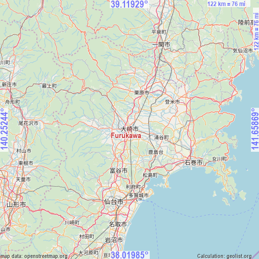
| Upper-left | 39.11929°, | 140.25244° |
| Center: | 38.57167°, | 140.95556° |
| Lower-right: | 38.01985°, | 141.65869° |
| Map W x H: | 122.2×122.2 km | = 75.9×75.9mi |
| max Lat: | 45.40944° ⇑10.3% North |
| Furukawa: | 38.57167° |
| min Lat: | ⇓89.7% South 24.34478° |
| min Long | Furukawa | max Long |
| 123° | 140.95556° | 145.575° |
| W 92.1%⇐ | ⇒7.9% E |
Elevation
Elevation of Furukawa is 23 m = 75 ft, and this is 61.6 m = 202 ft below average elevation for this country.
| Max E: |
1086 m = 3563 ft | 55.4% |
| Avg. | 84.6 m = 278 ft | |
| Furukawa | 23 m = 75 ft | |
Min E: |
-2 m = -7 ft | 44.6% |
See also: Furukawa elevation on elevation.city.
Geographical zone
Furukawa is located in North temperate zone (between Tropic of Cancer and the Arctic Circle). Distance of this Northern Tropic circle is 1682.8 km =1045.6 mi to South.| Distance of | km | miles | from Furukawa |
|---|---|---|---|
| North Pole | 5718.3 | 3553.2 | to North |
| Arctic Circle | 3112.4 | 1934 | to North |
| Tropic Cancer | 1682.8 | 1045.6 | to South |
| Equator | 4288.8 | 2664.9 | to South |


Nearby cities:
15 places around Furukawa: (largest is in red/bold)
• Higashimatsushima
26.6 km =16.5 mi,  132°
132°
• Ichinoseki
41.3 km =25.7 mi,  21°
21°
• Ishinomaki
34.6 km =21.5 mi,  119°
119°
• Kogota
8.6 km =5.3 mi,  106°
106°
• Kurihara
20.2 km =12.6 mi,  11°
11°
• Matsushima
23.9 km =14.9 mi,  157°
157°
• Rifu
26.8 km =16.7 mi,  176°
176°
• Sendai
34.8 km =21.6 mi,  192°
192°
• Shiogama
29.2 km =18.1 mi,  166°
166°
• Tagajō-shi
30.5 km =19 mi, 172°
• Tome
23.1 km =14.4 mi,  48°
48°
• Tomiya
20.8 km =12.9 mi,  196°
196°
• Wakuya
15.9 km =9.9 mi,  100°
100°
• Yamoto
27.7 km =17.2 mi, 125°
• Ōsaki
2.4 km =1.5 mi,  38°
38°
Sources, notices
• [Note1] Compared only with cities in Japan existing in our database
• [Src1] Map data: © OpenStreetMap contributors (CC-BY-SA)
• [Src2] Other city data from geonames.org with taken over terms of usage.
• [Src3] Geographical zone / Annual Mean Temperature by Robert A. Rohde @ Wikipedia
