Kogota geodata
Kogota (Miyagi) is a populated place; located in Japan in Asia/Tokyo (GMT+9) time zone. With population of 19,760 people, there are 699 cities with bigger population in this country. Compared to other cities in Japan, 89.6% of cities are located further ↓South; 93.1% of cities are located further ←West and 73.6% of cities have higher elevation than Kogota. Note1


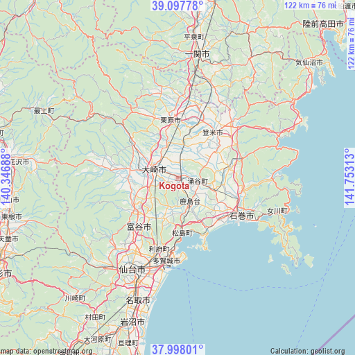
Kogota GPS coordinates[2]
38° 33' 0" North, 141° 3' 0" East
| Map corner | latitude | longitude |
|---|---|---|
| Upper-left | 39.09778°, | 140.34688° |
| Center: | 38.55°, | 141.05° |
| Lower-right: | 37.99801°, | 141.75313° |
| Map W x H: | 122.3×122.3 km | = 76×76mi |
| max Lat: | 45.40944° ⇑10.4% North |
| Kogota: | 38.55° |
| min Lat: | ⇓89.6% South 24.34478° |
| min Long | Kogota | max Long |
| 123° | 141.05° | 145.575° |
| W 93.1%⇐ | ⇒6.9% E |
Elevation
Elevation of Kogota is 10 m = 33 ft, and this is 74.6 m = 245 ft below average elevation for this country.
| Max E: |
1086 m = 3563 ft | 73.6% |
| Avg. | 84.6 m = 278 ft | |
| Kogota | 10 m = 33 ft | |
Min E: |
-2 m = -7 ft | 26.4% |
See also: Japan elevation on elevation.city.
Geographical zone
Kogota is located in North temperate zone (between Tropic of Cancer and the Arctic Circle). Distance of this Northern Tropic circle is 1680.4 km =1044.2 mi to South.| Distance of | km | miles | from Kogota |
|---|---|---|---|
| North Pole | 5720.7 | 3554.7 | to North |
| Arctic Circle | 3114.8 | 1935.4 | to North |
| Tropic Cancer | 1680.4 | 1044.2 | to South |
| Equator | 4286.4 | 2663.4 | to South |


Nearby cities:
15 places around Kogota: (largest is in red/bold)
• Furukawa
8.6 km =5.3 mi,  286°
286°
• Higashimatsushima
19.3 km =12 mi,  144°
144°
• Ishinomaki
26.3 km =16.3 mi,  124°
124°
• Kurihara
22.7 km =14.1 mi,  348°
348°
• Matsushima
19.6 km =12.2 mi,  177°
177°
• Onagawa Chō
36.5 km =22.7 mi,  108°
108°
• Rifu
25.2 km =15.7 mi,  194°
194°
• Sendai
35.3 km =21.9 mi,  206°
206°
• Shiogama
26 km =16.2 mi, 183°
• Tagajō-shi
28.1 km =17.5 mi, 188°
• Tome
19.9 km =12.4 mi,  27°
27°
• Tomiya
22.5 km =14 mi,  219°
219°
• Wakuya
7.4 km =4.6 mi,  94°
94°
• Yamoto
19.8 km =12.3 mi,  133°
133°
• Ōsaki
8 km =5 mi,  302°
302°
Sources, notices
• [Note1] Compared only with cities in Japan existing in our database
• [Src1] Map data: © OpenStreetMap contributors (CC-BY-SA)
• [Src2] Other city data from geonames.org with taken over terms of usage.
• [Src3] Geographical zone / Annual Mean Temperature by Robert A. Rohde @ Wikipedia
